File:Seal of Ivan 4 1539 a.svg
Jump to navigation
Jump to search

Size of this PNG preview of this SVG file: 478 × 485 pixels. Other resolutions: 237 × 240 pixels | 473 × 480 pixels | 757 × 768 pixels | 1,009 × 1,024 pixels | 2,018 × 2,048 pixels.
Original file (SVG file, nominally 478 × 485 pixels, file size: 338 KB)
Captions
Captions
Add a one-line explanation of what this file represents
Moscú de escudo
Summary
[edit]
| Description |
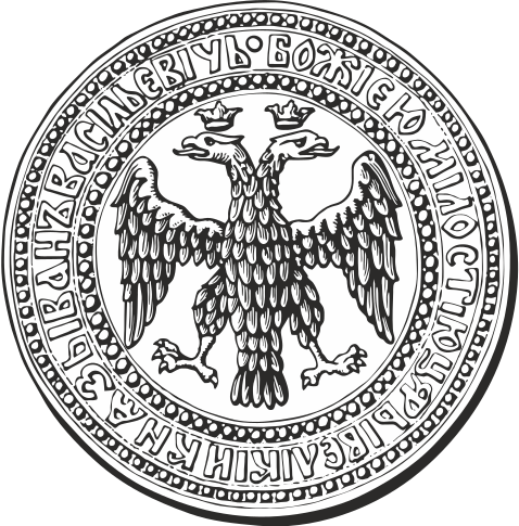
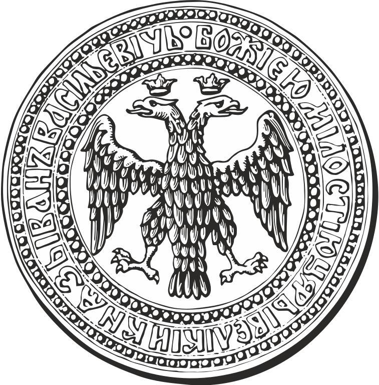
Русский: Малая печать Ивана IV Васильевича. Лицевая (двуглавый царский орел) сторона. Прорись по А. Б. Лакиеру. English: Russian coat of arms during the reign of Ivan Grozny. Seal of Ivan IV. 1539. |
| Date | |
| Source | Own work |
| Author | Лобачев Владимир |
Licensing
[edit]
I, the copyright holder of this work, hereby publish it under the following license:
| This file is made available under the Creative Commons CC0 1.0 Universal Public Domain Dedication. | |
| The person who associated a work with this deed has dedicated the work to the public domain by waiving all of their rights to the work worldwide under copyright law, including all related and neighboring rights, to the extent allowed by law. You can copy, modify, distribute and perform the work, even for commercial purposes, all without asking permission.
|
File history
Click on a date/time to view the file as it appeared at that time.
| Date/Time | Thumbnail | Dimensions | User | Comment | |
|---|---|---|---|---|---|
| current | 06:24, 5 October 2014 | | 478 × 485 (338 KB) | Лобачев Владимир (talk | contribs) | User created page with UploadWizard |
You cannot overwrite this file.
File usage on Commons
The following 26 pages use this file:
- File:Russian coa 1539 grozny.png
- File:Seal-of-Ivan-4 1539 a.svg (file redirect)
- File:Seal of Ivan 4 1539 a.png
- Template:Maps of Muscovy by century
- Template:MuscovyMapCat
- Template:MuscovyMapsDecade
- Category:1490s maps of Muscovy
- Category:1500s maps of Muscovy
- Category:1502 maps of Muscovy
- Category:1507 maps of Muscovy
- Category:1510s maps of Muscovy
- Category:1516 maps of Muscovy
- Category:1517 maps of Muscovy
- Category:1520s maps of Muscovy
- Category:1525 maps of Muscovy
- Category:1529 maps of Muscovy
- Category:1530s maps of Muscovy
- Category:1539 maps of Muscovy
- Category:1540s maps of Muscovy
- Category:1544 maps of Muscovy
- Category:1545 maps of Muscovy
- Category:15th-century maps of Muscovy
- Category:16th-century maps of Muscovy
- Category:Old maps of Muscovy
File usage on other wikis
The following other wikis use this file:
- Usage on af.wikipedia.org
- Usage on az.wikipedia.org
- Usage on be-tarask.wikipedia.org
- Usage on be.wikipedia.org
- Usage on bg.wikipedia.org
- Usage on bn.wikipedia.org
- Usage on ca.wikipedia.org
- Usage on ce.wikipedia.org
- Usage on cs.wikipedia.org
- Usage on de.wikipedia.org
- Usage on el.wikipedia.org
- Usage on en.wikipedia.org
- List of former sovereign states
- Coat of arms of Russia
- Great Perm
- Tsardom of Russia
- Russian heraldry
- List of wars involving Lithuania
- Vychegda Perm
- Principality of Tver
- List of sovereign states in 1500
- Principality of Odoyev
- Principality of Belyov
- Draft:List of armed conflicts involving Germany against Russia
- Usage on es.wikipedia.org
- Usage on et.wikipedia.org
- Usage on eu.wikipedia.org
- Usage on fa.wikipedia.org
- Usage on fi.wikipedia.org
- Usage on he.wikipedia.org
- Usage on id.wikipedia.org
- Usage on incubator.wikimedia.org
View more global usage of this file.