File:Scots lang-fr.svg
Jump to navigation
Jump to search

Size of this PNG preview of this SVG file: 508 × 599 pixels. Other resolutions: 203 × 240 pixels | 407 × 480 pixels | 651 × 768 pixels | 868 × 1,024 pixels | 1,737 × 2,048 pixels | 2,400 × 2,830 pixels.
Original file (SVG file, nominally 2,400 × 2,830 pixels, file size: 864 KB)
Captions
Captions
Add a one-line explanation of what this file represents
Summary
[edit]| Description |
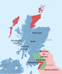
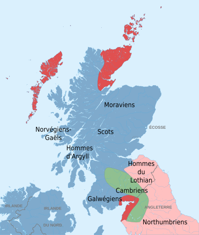
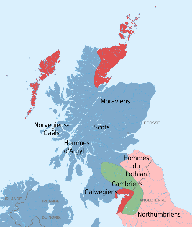
English: Map in French of Ethnic divisions in Scotland. Français : Carte en français des peuples d'Écosse aux environs de l'an 1100 (en gris les frontières actuelles (2010)). Langue gaélique Langues gaélique et norse Langue anglaise Langue cambrienne, ou plus vraisemblablement un mélange de cambrien, de gaélique et d'anglais. |
| Date | |
| Source |
Own work based on: Scotland map-fr.svg
|
| Author |
|
| Other versions |
|
| SVG development |


Licensing
[edit]
This file is licensed under the Creative Commons Attribution-Share Alike 3.0 Unported license.
- You are free:
- to share – to copy, distribute and transmit the work
- to remix – to adapt the work
- Under the following conditions:
- attribution – You must give appropriate credit, provide a link to the license, and indicate if changes were made. You may do so in any reasonable manner, but not in any way that suggests the licensor endorses you or your use.
- share alike – If you remix, transform, or build upon the material, you must distribute your contributions under the same or compatible license as the original.
Original upload log
[edit]
This image is a derivative work of the following images:
- Scotland map-fr.svg licensed with Cc-by-sa-3.0,2.5,2.0,1.0, GFDL
- 2008-09-05T01:52:24Z Sting 2400x3450 (4554601 Bytes) New standard colors
- 2007-12-14T01:21:07Z Sting 2400x3450 (4571299 Bytes) Additional name
- 2007-12-13T19:31:29Z Sting 2400x3450 (4569689 Bytes) {{Location|57|00|00|N|04|00|00|W|scale:4000000}} {{Information |Description=Map in French of [[:en:Scotland|Scotland]] |Source=Own work ;Shore / lakes contours and shaded relief : [http://www2.jpl.nasa.gov/srtm NASA Shuttle
- Peuplesdecosse.png licensed with Cc-by-sa-2.5
- 2006-05-10T19:11:27Z Ayack 1102x2000 (233736 Bytes) {{Information| |Description=Carte des peuples écossais vers l'an 1100. |Source=Based on various maps and studdies , including those of Driscoll, Alba: The Gaelic Kingdom of Scotland, AD 800-1124; Nicolaisen, Scottish Place N
Uploaded with derivativeFX
File history
Click on a date/time to view the file as it appeared at that time.
| Date/Time | Thumbnail | Dimensions | User | Comment | |
|---|---|---|---|---|---|
| current | 20:51, 29 November 2010 | | 2,400 × 2,830 (864 KB) | Ayack (talk | contribs) | {{Information |Description={{en|Map in French of Ethnic divisions in Scotland.}} {{fr|Carte en français des peuples d'Écosse aux environs de l'an 1100.<br/>{{Légende|#7FAACC|Langue gaélique}}{{Légende|#E05050|Langues |
You cannot overwrite this file.
File usage on Commons
The following page uses this file:
File usage on other wikis
The following other wikis use this file:
- Usage on fr.wikipedia.org