File:Scorpiones distribution.png
Jump to navigation
Jump to search

Size of this preview: 800 × 388 pixels. Other resolutions: 320 × 155 pixels | 640 × 310 pixels | 1,295 × 628 pixels.
Original file (1,295 × 628 pixels, file size: 54 KB, MIME type: image/png)
Captions
Captions
Add a one-line explanation of what this file represents
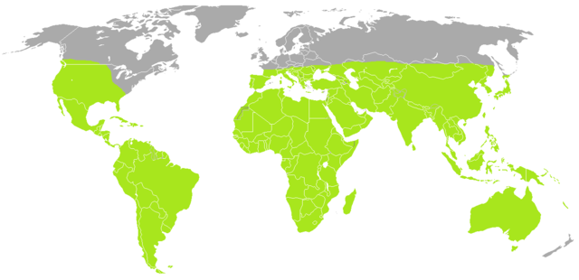
| Description | A blank map of the world as of 2008, with country outlines, for making country locator maps. This map uses the Robinson projection centered on the Greenwich Prime Meridian and includes various microstates and island nations. All territories indicated in the UN listing of territories and regions are exhibited. |
| Date | (UTC) |
| Source | |
| Author |
|
| This is a retouched picture, which means that it has been digitally altered from its original version. Modifications: coloured. The original can be viewed here: BlankMap-World-Current.png: File:BlankMap-World-Current.png. Modifications made by B kimmel.
|
| I, the copyright holder of this work, release this work into the public domain. This applies worldwide. In some countries this may not be legally possible; if so: I grant anyone the right to use this work for any purpose, without any conditions, unless such conditions are required by law. |
Original upload log[edit]
This image is a derivative work of the following images:
- File:BlankMap-World.png licensed with PD-user
- 2010-06-11T08:50:57Z Doopy 1480x628 (58752 Bytes) {{Information |Description=A blank map of the world as of 2008, with country outlines, for making country locator maps. This map uses the [[:en:Robinson projection|Robinson projection]] centered on the Greenwich Prime Meridi
File history
Click on a date/time to view the file as it appeared at that time.
| Date/Time | Thumbnail | Dimensions | User | Comment | |
|---|---|---|---|---|---|
| current | 16:47, 3 July 2010 | | 1,295 × 628 (54 KB) | B kimmel (talk | contribs) | orange = green |
| 10:20, 29 June 2010 |  | 1,295 × 628 (54 KB) | B kimmel (talk | contribs) | {{Information |Description=A blank map of the world as of 2008, with country outlines, for making country locator maps. This map uses the Robinson projection centered on the Greenwich Prime Meridian and includes various [[:en: |
You cannot overwrite this file.
File usage on Commons
There are no pages that use this file.
File usage on other wikis
The following other wikis use this file:
- Usage on ast.wikipedia.org
- Usage on azb.wikipedia.org
- Usage on br.wikipedia.org
- Usage on en.wikipedia.org
- Usage on eo.wikipedia.org
- Usage on es.wikipedia.org
- Usage on eu.wikipedia.org
- Usage on fi.wikipedia.org
- Usage on fr.wikipedia.org
- Usage on he.wikipedia.org
- Usage on id.wikipedia.org
- Usage on kw.wikipedia.org
- Usage on mrj.wikipedia.org
- Usage on my.wikipedia.org
- Usage on nl.wikipedia.org
- Usage on os.wikipedia.org
- Usage on ro.wikipedia.org
- Usage on ru.wikipedia.org
- Usage on sco.wikipedia.org
- Usage on simple.wikipedia.org
- Usage on sr.wikipedia.org
- Usage on th.wikipedia.org
- Usage on tl.wikipedia.org
- Usage on tr.wikipedia.org