File:Schwanenburg-elte-lidar.png
Jump to navigation
Jump to search

Size of this preview: 800 × 463 pixels. Other resolutions: 320 × 185 pixels | 640 × 371 pixels | 1,280 × 741 pixels.
Original file (1,280 × 741 pixels, file size: 2.03 MB, MIME type: image/png)
Captions
Captions
Add a one-line explanation of what this file represents
Summary[edit]
| Description |
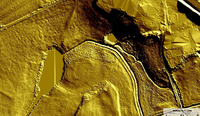
Deutsch: https://www.tim-online.nrw.de/tim-online2/
Digitales Geländemodell: Schummerung, Helligkeit und Kontrast abgeändert. Zeigt in der Bildmitte halb ringförmig den verschütteten Burggraben der ehemaligen Schwanenburg in Elte. |
| Date | |
| Source | tim-online.de |
| Author | User:Zumthie |

|
This file is licensed under the terms of the Data licence Germany – Zero – version 2.0 |
|
Any use is permitted without restrictions or conditions.
|
| Camera location | | View this and other nearby images on: OpenStreetMap |
|---|
Licensing[edit]
File history
Click on a date/time to view the file as it appeared at that time.
| Date/Time | Thumbnail | Dimensions | User | Comment | |
|---|---|---|---|---|---|
| current | 21:01, 17 January 2022 | | 1,280 × 741 (2.03 MB) | Zumthie (talk | contribs) | Uploaded a work by User:Zumthie from https://www.tim-online.nrw.de/tim-online2/ with UploadWizard |
You cannot overwrite this file.
File usage on Commons
There are no pages that use this file.
File usage on other wikis
The following other wikis use this file:
- Usage on de.wikipedia.org