File:Schengen Area (Lablled Map).png
Jump to navigation
Jump to search

Size of this preview: 606 × 599 pixels. Other resolutions: 243 × 240 pixels | 485 × 480 pixels | 777 × 768 pixels | 1,035 × 1,024 pixels | 2,071 × 2,048 pixels | 2,831 × 2,800 pixels.
Original file (2,831 × 2,800 pixels, file size: 901 KB, MIME type: image/png)
Captions
Captions
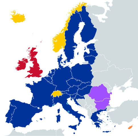
Map of the Schengen Area (October 2020)
Summary
[edit].png&action=edit§ion=1)
| Description |
English: A map of the Schengen Area as of January 2023, indicating; EU member-states, EU member-states (air and maritime borders only), Non-EU member-states, Non-EU member-states de facto participating, EU and former EU member-states outside the Schengen Area, and EU member-states working towards Schengen implementation Created using https://mapchart.net/europe.html |
| Date | |
| Source | Own work |
| Author | ZElsb |
Licensing
[edit].png&action=edit§ion=2)
I, the copyright holder of this work, hereby publish it under the following license:
This file is licensed under the Creative Commons Attribution-Share Alike 4.0 International license.
- You are free:
- to share – to copy, distribute and transmit the work
- to remix – to adapt the work
- Under the following conditions:
- attribution – You must give appropriate credit, provide a link to the license, and indicate if changes were made. You may do so in any reasonable manner, but not in any way that suggests the licensor endorses you or your use.
- share alike – If you remix, transform, or build upon the material, you must distribute your contributions under the same or compatible license as the original.
File history
Click on a date/time to view the file as it appeared at that time.
| Date/Time | Thumbnail | Dimensions | User | Comment | |
|---|---|---|---|---|---|
| current | 06:40, 3 June 2024 | | 2,831 × 2,800 (901 KB) | Thearones (talk | contribs) | Andorra (https://www.auswaertiges-amt.de/de/service/visa-und-aufenthalt/schengen/207786?enodia=eyJleHAiOjE3MTczMzYyNTYsImNvbnRlbnQiOnRydWUsImF1ZCI6ImF1dGgiLCJIb3N0Ijoid3d3LmF1c3dhZXJ0aWdlcy1hbXQuZGUiLCJTb3VyY2VJUCI6IjE5Mi40Mi4xMTYuMTgzIiwiQ29uZmlnSUQiOiI4ZGFkY2UxMjVmZDJjMzkzMmI5NDNiNTJlOWQyY2Q2NTA1NzU0ZTE2MjIxMmEyY2UxYmI1YWYxNWMwZDRiYmZlIn0=.Kmo7KJpPY6Jl7kyHVksveFQ4y_OtZZWpLfDh6My6ZXI=#content_6) |
| 06:24, 25 April 2024 |  | 2,831 × 2,800 (1.08 MB) | ZElsb (talk | contribs) | Altered colours | |
| 09:14, 1 April 2024 |  | 2,831 × 2,771 (1.08 MB) | ZElsb (talk | contribs) | Updated colours and changed RO and BG to reflect their partial Schengen entry | |
| 19:07, 16 January 2023 |  | 2,772 × 2,830 (711 KB) | Hanzlan (talk | contribs) | Added Malta | |
| 03:37, 1 January 2023 |  | 2,772 × 2,830 (711 KB) | GamerOfStrategy (talk | contribs) | Added Croatia | |
| 10:36, 12 January 2021 |  | 2,772 × 2,830 (634 KB) | Nablicus (talk | contribs) | Added Luxembourg | |
| 04:25, 9 October 2020 |  | 2,772 × 2,830 (1.04 MB) | ZElsb (talk | contribs) | Uploaded own work with UploadWizard |
You cannot overwrite this file.
File usage on Commons
The following page uses this file:
File usage on other wikis
The following other wikis use this file:
- Usage on bs.wikipedia.org
- Usage on en.wikipedia.org
- Usage on pt.wikipedia.org
- Usage on ur.wikipedia.org
- Usage on zh.wikipedia.org
.png&oldid=881005789)