File:Schauinsland-blizzard-disaster.png

From Wikimedia Commons, the free media repository
Jump to navigation Jump to search

Original file(696 × 888 pixels, file size: 693 KB, MIME type: image/png)

Captions

Captions

Add a one-line explanation of what this file represents
Description
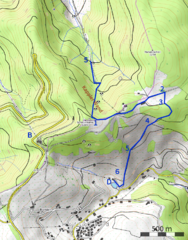
English: Probable route of the students group through the 1936 blizzard, according to local research and witness reports.
  • S = Meeting postman Otto Steiert, then ascent up the Kappler Wand
  • 1 = Arrival on ridge, drawn eastward by the storm
  • 2 = Probably first overhearing of bells, might explain for the change of direction
  • 3 = place where Jack Eaton was found with two survivors
  • 4 = place where Francis Bourdillon and Roy Witham were found, together with Keast and another survivor
  • 5 = place where Peter Ellercamp was found, with one survivor
  • 6 = place where Stanley Lyons was found, just above Dobelhof
  • D = Dobelhof farmhouse
  • B = Mountain station of cable car (where nearest shelter could have been found)
Deutsch: Wahrscheinlicher Weg der Schülergruppe im Schneesturm 1936, nach lokalen Erkundungen und Zeugenaussagen.
  • S = Treffen mit Postmann Otto Steiert, dann Aufstieg über die Kappler Wand
  • 1 = Ankunft Ostkamm, vom Sturm nach Osten abgedrängt
  • 2 = Möglicherweise erstes Vernehmen der Kirchenglocken, das würde die Richtungsänderung erklären
  • 3 = Fundort Jack Eaton mit zwei Überlebenden
  • 4 = Fundort Francis Bourdillon und Roy Witham mit Keast und einem weiteren Überlebenden
  • 5 = Fundort Peter Ellercamp mit einem Überlebenden
  • 6 = Fundort Stanley Lyons, kurz oberhalb des Dobelhofs
  • D = Dobelhof
  • B = Bergstation Schauinslandbahn (wäre die nächste Schutzmöglichkeit gewesen)
Date
Source Own work
Author Kreuzschnabel; map layout: OpenTopoMap; map data: OpenStreetMap contributors
Permission
(Reusing this file)
Image by Kreuzschnabel/Wikimedia Commons, License: artlibre

Licensing: Choose any of the following licenses for reuse of this work. Usage is free of charge as long as all terms of the license chosen are complied with. If you would like alternative terms, please get in touch with me via Wikimail or leave a request on my my discussion page to negotiate.

  • Using online: A typical example of reusing my images is given at the right, showing the author’s name and a link to the license used.
  • Using in printed media: Either close to the image or in a separate image directory, as long as unambiguously assigned, the author and license used should be specified, like: Photo: Kreuzschnabel/Wikimedia Commons, Licence: Cc-by-sa-3.0 (https://creativecommons.org/licenses/by-sa/3.0/legalcode)

In any case, I should be glad to receive a Wikimail message or, for printed media, a sample copy.

→ More information about reuse outside Wikimedia projects.

This file is copyrighted and has been released under licenses which are incompatible with Facebook's licensing terms. Therefore, it is not permitted to upload this file to Facebook. This applies accordingly to a large number of other social networks or other interactive sites.

I, the copyright holder of this work, hereby publish it under the following license:
w:en:Creative Commons
attribution share alike
This file is licensed under the Creative Commons Attribution-Share Alike 3.0 Unported license.
You are free:
  • to share – to copy, distribute and transmit the work
  • to remix – to adapt the work
Under the following conditions:
  • attribution – You must give appropriate credit, provide a link to the license, and indicate if changes were made. You may do so in any reasonable manner, but not in any way that suggests the licensor endorses you or your use.
  • share alike – If you remix, transform, or build upon the material, you must distribute your contributions under the same or compatible license as the original.
Description
This map was created from OpenStreetMap project data, collected by the community. This map may be incomplete, and may contain errors. Don't rely solely on it for navigation.
Date (see file history)
Source openstreetmap.org
Creator
OpenStreetMap contributors
Permission
(Reusing this file)

OpenStreetMap data is available under the Open Database License (details). Map tiles are licensed under the Creative Commons Attribution-ShareAlike 2.0 license (CC-BY-SA 2.0).

This work contains information from OpenStreetMap, which is made available under the Open Database License (ODbL).

The ODbL does not require any particular license for maps produced from ODbL data. Prior to 1 August 2020, map tiles produced by the OpenStreetMap Foundation were licensed under the CC-BY-SA-2.0 license. Maps produced by other people may be subject to other licences.

w:en:Creative Commons
attribution share alike
This file is licensed under the Creative Commons Attribution-Share Alike 2.0 Generic license.
You are free:
  • to share – to copy, distribute and transmit the work
  • to remix – to adapt the work
Under the following conditions:
  • attribution – You must give appropriate credit, provide a link to the license, and indicate if changes were made. You may do so in any reasonable manner, but not in any way that suggests the licensor endorses you or your use.
  • share alike – If you remix, transform, or build upon the material, you must distribute your contributions under the same or compatible license as the original.
Georeferencing Georeference the map in Wikimaps Warper If inappropriate please set warp_status = skip to hide.

File history

Click on a date/time to view the file as it appeared at that time.

Date/TimeThumbnailDimensionsUserComment
current12:04, 3 October 2016Thumbnail for version as of 12:04, 3 October 2016696 × 888 (693 KB)Kreuzschnabel (talk | contribs)crop to essential region
10:56, 3 October 2016Thumbnail for version as of 10:56, 3 October 20161,199 × 1,044 (1.41 MB)Kreuzschnabel (talk | contribs){{Information |Description ={{en|1=Probable route of the students group through the 1936 blizzard, according to local research and witnesses. S = Meeting postman Otto Steiert, then ascent up the Kappler Wand 1 = Arrival on ridge, drawn eastward by...

File usage on other wikis

The following other wikis use this file:

Metadata