File:Schönheide mit Ziegenleite und Juchhöh Ansichtskarte etwa 1920.jpg
Jump to navigation
Jump to search

Size of this preview: 800 × 503 pixels. Other resolutions: 320 × 201 pixels | 640 × 402 pixels | 1,024 × 644 pixels | 1,280 × 804 pixels | 2,560 × 1,609 pixels | 4,296 × 2,700 pixels.
Original file (4,296 × 2,700 pixels, file size: 3.23 MB, MIME type: image/jpeg)
Captions
Captions
Add a one-line explanation of what this file represents
Summary[edit]
| Description |
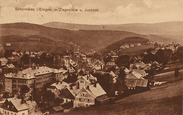
Deutsch: Schönheide im Erzgebirge: Ansichtskarte mit dem unteren Ortsteil. Besonders erwähnt werden auf der Karte die Ortsteile Buchhöhe (rechts davon die Hammerschule, Schule des Ortsteils Schönheiderhammer, mit ihrem Glockenturm) und Ziegenleithe. Im vorderen Bereich ist das große Gebäude der zwischen 1896 und 1898 errichteten Schule zu sehen (Geschwister-Scholl-Schule (Schönheide)). |
| Date | circa 1920 |
| Source | Scan of a postcard from about 1920 |
| Author | Unknown author |
| Permission (Reusing this file) |
This image is in the public domain due to its age. |
| Camera location | | View this and other nearby images on: OpenStreetMap |
|---|
| Object location | | View this and other nearby images on: OpenStreetMap |
|---|
Licensing[edit]
|
This work is in the public domain in its country of origin and other countries and areas where the copyright term is the author's life plus 70 years or fewer. This work is in the public domain in the United States because it was published (or registered with the U.S. Copyright Office) before January 1, 1929. | |
| This file has been identified as being free of known restrictions under copyright law, including all related and neighboring rights. | |
| Annotations | This image is annotated: View the annotations at Commons |
File history
Click on a date/time to view the file as it appeared at that time.
| Date/Time | Thumbnail | Dimensions | User | Comment | |
|---|---|---|---|---|---|
| current | 11:23, 27 November 2018 | | 4,296 × 2,700 (3.23 MB) | Klaaschwotzer (talk | contribs) | {{Information |description ={{de|1=Schönheide im Erzgebirge: Ansichtskarte mit dem unteren Ortsteil. Besonders erwähnt werden auf der Karte die Ortsteile Buchhöhe (rechts davon die Hammerschule, Schule des Ortsteils Schönheiderhammer, mit ihrem Glockenturm) und Ziegenleithe. Im vorderen Bereich ist das große Gebäude der zwischen 1896 und 1898 errichteten Schule zu sehen ([[:de:Geschwister-Scholl-Schule (Schön... |
You cannot overwrite this file.
File usage on Commons
The following page uses this file:
File usage on other wikis
The following other wikis use this file:
- Usage on de.wikipedia.org
- Usage on www.wikidata.org