File:Satellite image Salar de Uyuni - Coipasa - Lake Poopo.jpg
Jump to navigation
Jump to search

Size of this preview: 600 × 600 pixels. Other resolutions: 240 × 240 pixels | 639 × 639 pixels.
Original file (639 × 639 pixels, file size: 337 KB, MIME type: image/jpeg)
Captions
Captions
Add a one-line explanation of what this file represents
Summary[edit]
| Description |
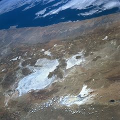
English: Satellite image of Salar de Uyuni - Salar de Coipasa - Lake Poopo, Bolivia. (North at right)
Lake Poopo, Salar de Uyuni, Bolivia September 1996. Numerous bright salars or salt flats are visible in this westerly view of the southwestern part of the Altiplano in Bolivia. Many volcanic cones (darker, roughly circular features) are visible, mainly along the western flanks of the two large salars, Uyuni (largest) and Coipasa. Lake Poopo, a light colored feature northeast of the two large salars, appears to be relatively devoid of standing water at the time this image was obtained. Some clouds partially obscure the southern end of intermittently water filled Lake Poopo. The Andes Mountains dramatically decrease in elevation in a relatively short horizontal distance along the western slopes of the mountains. Known as the Atacama Desert of northern Chile, this synoptic view shows a large section of one of the most arid regions on earth. Italiano: Immagine satellitare del Salar de Uyuni - Salar de Coipasa - Lago Poopo, Bolivia. (Nord a destra) |
| Date | |
| Source | NASA |
| Author | NASA |
| Permission (Reusing this file) |
PD NASA |
This image or video was catalogued by one of the centers of the United States National Aeronautics and Space Administration (NASA) under Photo ID: STS079-785-16. This tag does not indicate the copyright status of the attached work. A normal copyright tag is still required. See Commons:Licensing. Other languages:
|
Licensing[edit]
| This file is in the public domain in the United States because it was solely created by NASA. NASA copyright policy states that "NASA material is not protected by copyright unless noted". (See Template:PD-USGov, NASA copyright policy page or JPL Image Use Policy.) | ||
 |
Warnings:
|
File history
Click on a date/time to view the file as it appeared at that time.
| Date/Time | Thumbnail | Dimensions | User | Comment | |
|---|---|---|---|---|---|
| current | 11:18, 22 February 2006 | | 639 × 639 (337 KB) | Luigi Chiesa (talk | contribs) | {{Information| |Description = <br/> *{{en|Satellite image of Salar de Uyuni - Salar de Coipasa - Lake Poopo, Bolivia. (North at right)}} *{{it|Immagine satellitare del Salar de Uyuni - Salar de Coipasa - Lago Poopo, Bolivia. (Nord a destra)}} |Source |
You cannot overwrite this file.
File usage on Commons
The following page uses this file:
File usage on other wikis
The following other wikis use this file:
- Usage on ast.wikipedia.org
- Usage on de.wikipedia.org
- Usage on es.wikipedia.org
- Usage on fr.wikipedia.org
- Usage on qu.wikipedia.org