File:Sankarani river map.png
Jump to navigation
Jump to search
Size of this preview: 179 × 597 pixels. Other resolution: 200 × 667 pixels.
Original file (200 × 667 pixels, file size: 59 KB, MIME type: image/png)
Captions
Captions
Add a one-line explanation of what this file represents
Summary
[edit]
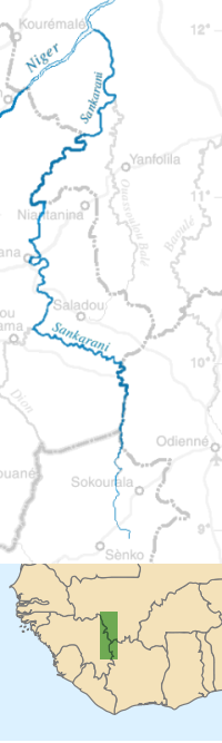
| Description | Map of the Sankarani river in Cote d'Ivoire, Guinea, and Mali. | ||
| Date | |||
| Source | self-made, with the Gimp, from a blank PD map of West Africa in Wikipedia Commons | ||
| Author | T L Miles | ||
| Permission (Reusing this file) |
|
Licensing
[edit]
| I, the copyright holder of this work, release this work into the public domain. This applies worldwide. In some countries this may not be legally possible; if so: I grant anyone the right to use this work for any purpose, without any conditions, unless such conditions are required by law. |
File history
Click on a date/time to view the file as it appeared at that time.
| Date/Time | Thumbnail | Dimensions | User | Comment | |
|---|---|---|---|---|---|
| current | 21:59, 7 March 2008 | 200 × 667 (59 KB) | T L Miles (talk | contribs) | {{Information |Description=Map of the Sankarani river in Cote d'Ivoire, Guinea, and Mali. |Source=self-made, with the Gimp, from a blank PD map of West Africa in Wikipedia Commons |Date=2008-02-07 |Author= T L Miles |Permission={{PD}} | |
You cannot overwrite this file.
File usage on Commons
The following page uses this file:
File usage on other wikis
The following other wikis use this file:
- Usage on cs.wikipedia.org
- Usage on en.wikipedia.org
- Usage on eo.wikipedia.org
- Usage on es.wikipedia.org
- Usage on fi.wikipedia.org
- Usage on fr.wikipedia.org
- Usage on lt.wikipedia.org
- Usage on pt.wikipedia.org
- Usage on ru.wikipedia.org
- Usage on www.wikidata.org
- Usage on zh.wikipedia.org