File:Sandzak ethnic map.png
Jump to navigation
Jump to search

Size of this preview: 420 × 599 pixels. Other resolutions: 168 × 240 pixels | 550 × 785 pixels.
Original file (550 × 785 pixels, file size: 65 KB, MIME type: image/png)
Captions
Captions
Add a one-line explanation of what this file represents
Summary[edit]
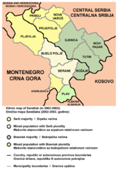
English: Ethnic map of Sandžak in 2002-2003.
Српски / srpski: Etnička mapa Sandžaka 2002-2003. godine.
Crnogorski: Etnička mapa Sandžaka 2002-2003. godine.
Bosanski: Etnička mapa Sandžaka 2002-2003. godine.
Source and license[edit]

|
This map has been uploaded by Electionworld from en.wikipedia.org to enable the |
Self-made map by PANONIAN
| This work has been released into the public domain by its author, PANONIAN. This applies worldwide. In some countries this may not be legally possible; if so: |
References[edit]
- Popis stanovništva, domaćinstava i stanova u 2002., Stanovništvo - knjiga 1, Nacionalna ili etnička pripadnost - podaci po naseljima, Republika Srbija, Republički zavod za statistiku, Beograd, 2003.
- Popis stanovništva, domaćinstava i stanova u 2003., Stanovništvo - knjiga 1, Nacionalna ili etnička pripadnost - podaci po naseljima i opštinama, Republika Crna Gora, Zavod za statistiku, Podgorica, 2004.
- Slobodan Radovanović, Geografski atlas, Magic Map, Smederevska Palanka, 2001.
- Geografski atlas, Intersistem kartografija, Beograd, 2004.
File history
Click on a date/time to view the file as it appeared at that time.
| Date/Time | Thumbnail | Dimensions | User | Comment | |
|---|---|---|---|---|---|
| current | 09:13, 21 May 2013 | | 550 × 785 (65 KB) | PANONIAN (talk | contribs) | improved version |
| 17:38, 9 March 2008 |  | 473 × 578 (63 KB) | Gugganij (talk | contribs) | highlighted Serbian-Montenegrin border | |
| 21:42, 21 December 2006 |  | 473 × 578 (67 KB) | Electionworld (talk | contribs) | {{ew|en|PANONIAN}} Self-made map by PANONIAN {{PD-user|PANONIAN}} Category:Maps of Serbia Category:Maps of Montenegro |
You cannot overwrite this file.
File usage on Commons
The following 2 pages use this file:
File usage on other wikis
The following other wikis use this file:
- Usage on bs.wikipedia.org
- Usage on ca.wikipedia.org
- Usage on en.wikipedia.org
- Usage on fa.wikipedia.org
- Usage on gl.wikipedia.org
- Usage on he.wikipedia.org
- Usage on hr.wikipedia.org
- Usage on it.wikipedia.org
- Usage on ja.wikipedia.org
- Usage on lt.wikipedia.org
- Usage on mk.wikipedia.org
- Usage on no.wikipedia.org
- Usage on sh.wikipedia.org
- Usage on sr.wikipedia.org
- Usage on tr.wikipedia.org
- Usage on uk.wikipedia.org