File:Saint Petersburg Trolleybus System OSM Map.svg
Jump to navigation
Jump to search

Size of this PNG preview of this SVG file: 600 × 600 pixels. Other resolutions: 240 × 240 pixels | 480 × 480 pixels | 768 × 768 pixels | 1,024 × 1,024 pixels | 2,048 × 2,048 pixels | 3,750 × 3,750 pixels.
Original file (SVG file, nominally 3,750 × 3,750 pixels, file size: 4.77 MB)
Captions
Captions
Add a one-line explanation of what this file represents
Summary[edit]
| Description |
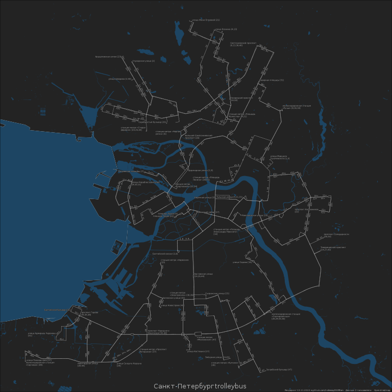
Русский: Карта маршрутов троллейбуса в Санкт-Петербурге English: Map of Saint Petersburg trolleybus lines. Generated with script https://github.com/trolleway/OSMTram automatically from OpenStreetMap dump
This vector image was created with QGIS. |
||||||||||||||||||||||||||
| Date | |||||||||||||||||||||||||||
| Source | Own work | ||||||||||||||||||||||||||
| Creator |
|
||||||||||||||||||||||||||
| Geotemporal data | |||||||||||||||||||||||||||
| Date depicted | after 2021 | ||||||||||||||||||||||||||
| Map location | Saint Petersburg | ||||||||||||||||||||||||||
| Spatial reference system | EPSG:3857 | ||||||||||||||||||||||||||
| Heading |
 |
||||||||||||||||||||||||||
| Bounding box |
|
||||||||||||||||||||||||||
| Georeferencing | If inappropriate please set warp_status = skip to hide. | ||||||||||||||||||||||||||
.jpg)

Licensing[edit]
| Description |
This map was created from OpenStreetMap project data, collected by the community. This map may be incomplete, and may contain errors. Don't rely solely on it for navigation. |
|||
| Date | (see file history) | |||
| Source | openstreetmap.org | |||
| Creator |
OpenStreetMap contributors |
|||
| Permission (Reusing this file) |
OpenStreetMap data is available under the Open Database License (details). Map tiles are licensed under the Creative Commons Attribution-ShareAlike 2.0 license (CC-BY-SA 2.0).
This file is licensed under the Creative Commons Attribution-Share Alike 2.0 Generic license.
|
|||
| Georeferencing | If inappropriate please set warp_status = skip to hide. |
File history
Click on a date/time to view the file as it appeared at that time.
| Date/Time | Thumbnail | Dimensions | User | Comment | |
|---|---|---|---|---|---|
| current | 10:42, 13 November 2022 | | 3,750 × 3,750 (4.77 MB) | Florstein (talk | contribs) | {{Map |description={{ru|1=Карта маршрутов троллейбуса в Санкт-Петербурге}}{{en|1=Map of Saint Petersburg trolleybus lines. Generated with script https://github.com/trolleway/OSMTram automatically from OpenStreetMap dump}} {{ Created with QGIS|v }} |date=2022-11-13 |map_date={{other date|after|2021}} |location=Saint Petersburg |projection=EPSG:3857 |heading=N |latitude=59.94 |longitude=30.33 |source={{own}} |author={{Creator:Artem Svetlov}} |permission= |other versions= }} =={{int:license-he... |
You cannot overwrite this file.
File usage on Commons
The following 3 pages use this file:
File usage on other wikis
The following other wikis use this file:
- Usage on ru.wikipedia.org
- Usage on www.wikidata.org