File:Saint-laurent-cassini.jpg
Jump to navigation
Jump to search
No higher resolution available.
Saint-laurent-cassini.jpg (590 × 390 pixels, file size: 59 KB, MIME type: image/jpeg)
Captions
Captions
Add a one-line explanation of what this file represents
Summary[edit]
| Description |
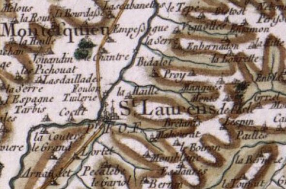
Français : Saint-Laurent, commune de la Haute-Garonne (31), figuré sur une carte de Cassini sous le nom de "Saint-Laurens de l'Isle" en 1770
Numérotation Cassini : 75 Numéro de parution : 98ème feuille (Tarbes) Dimension de la feuille : 60,5 x 95,5 cm Levés réalisés par Langelay (Ingénieur) et vérifiés par La Briffe (Ingénieur) Echelle 1/86400e |
| Date | between 1768 and 1770 |
| Source | Carte de Cassini visualisable sur le site de la Bibliothèque Nationale de France : http://gallica.bnf.fr/scripts/ConsultationTout.exe?E=0&O=07711587 |
| Author | Cassini |
Licensing[edit]
|
This work is in the public domain in its country of origin and other countries and areas where the copyright term is the author's life plus 100 years or fewer. | |
| This file has been identified as being free of known restrictions under copyright law, including all related and neighboring rights. | |
File history
Click on a date/time to view the file as it appeared at that time.
| Date/Time | Thumbnail | Dimensions | User | Comment | |
|---|---|---|---|---|---|
| current | 13:40, 16 January 2009 | | 590 × 390 (59 KB) | Saintlaurentsursave (talk | contribs) | {{Information |Description={{fr|1=Saint-Laurent, commune de la Haute-Garonne (31), figuré sur une carte de Cassini sous le nom de "Saint-Laurens de l'Isle" en 1770 Numérotation Cassini : 75 Numéro de parution : 98ème feuille (Tarbes) Dimension de |
You cannot overwrite this file.
File usage on Commons
There are no pages that use this file.
File usage on other wikis
The following other wikis use this file:
- Usage on fr.wikipedia.org