File:Sabotaged anemometry mast - geograph.org.uk - 532366.jpg
Jump to navigation
Jump to search

Size of this preview: 450 × 600 pixels. Other resolutions: 180 × 240 pixels | 480 × 640 pixels.
Original file (480 × 640 pixels, file size: 69 KB, MIME type: image/jpeg)
Captions
Captions
Add a one-line explanation of what this file represents
Summary[edit]
| Description |
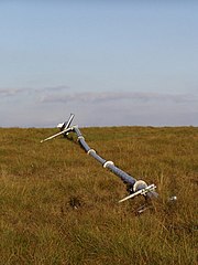
English: Sabotaged anemometry mast This mast was erected on Higher Hill to measure wind speed prior to the planning application for the Scout Moor wind farm. My recollection is that it was some 20 to 30 metres high. It was felled by cutting one of the four supporting cables sometime in the few days before this picture was taken in August 2003. This action is an indication of the strong feelings aroused by the wind farm scheme. |
| Date | |
| Source | From geograph.org.uk |
| Author | Mike Lee |
| Attribution (required by the license) | Mike Lee / Sabotaged anemometry mast / |
| Camera location | | View this and other nearby images on: OpenStreetMap |
|---|
_heading:90.00&language=en)
| Object location | | View this and other nearby images on: OpenStreetMap |
|---|
_heading:90.00&language=en)
Licensing[edit]

|
This image was taken from the Geograph project collection. See this photograph's page on the Geograph website for the photographer's contact details. The copyright on this image is owned by Mike Lee and is licensed for reuse under the Creative Commons Attribution-ShareAlike 2.0 license.
|
This file is licensed under the Creative Commons Attribution-Share Alike 2.0 Generic license.
Attribution: Mike Lee
- You are free:
- to share – to copy, distribute and transmit the work
- to remix – to adapt the work
- Under the following conditions:
- attribution – You must give appropriate credit, provide a link to the license, and indicate if changes were made. You may do so in any reasonable manner, but not in any way that suggests the licensor endorses you or your use.
- share alike – If you remix, transform, or build upon the material, you must distribute your contributions under the same or compatible license as the original.
File history
Click on a date/time to view the file as it appeared at that time.
| Date/Time | Thumbnail | Dimensions | User | Comment | |
|---|---|---|---|---|---|
| current | 20:56, 5 February 2011 | | 480 × 640 (69 KB) | GeographBot (talk | contribs) | == {{int:filedesc}} == {{Information |description={{en|1=Sabotaged anemometry mast This mast was erected on Higher Hill to measure wind speed prior to the planning application for the Scout Moor wind farm. My recollection is that it was some 20 to 30 metr |
You cannot overwrite this file.
File usage on Commons
There are no pages that use this file.