File:STS068-239-90 - Image of Taipei Area.jpg
From Wikimedia Commons, the free media repository
Jump to navigation
Jump to search

Size of this preview: 599 × 600 pixels. Other resolutions: 240 × 240 pixels | 479 × 480 pixels | 767 × 768 pixels | 1,022 × 1,024 pixels | 2,045 × 2,048 pixels | 4,085 × 4,091 pixels.
Original file (4,085 × 4,091 pixels, file size: 13.38 MB, MIME type: image/jpeg)
File information
Structured data
Captions
Captions
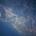
View of Taiwan taken by the crew of STS-68 in October 1994
Summary
[edit]| DescriptionSTS068-239-90 - Image of Taipei Area.jpg |
English: Located at the northern end of the island, Taipei (light colored area) is Taiwan capital and largest city (estimated 1997 population more than 2.6 million people). The Tanshui River (dark curving feature) flows through Taipei, eventually emptying into the Formosa Strait. Parallel runways (light-colored linear feature) of Chiang Kai Shek International Airport are visible west of Taipei near the coast. The Chungyang Mountains can be identified by the darker landscape, particularly in the lower right corner of the image. This mountain range extends northeast/southwest for the entire length of the island. The mountains tend to have steep slopes and are densely forested. The darker terrain along the west coast is vegetated hills, while the lighter colored terrain shows the distribution of urban areas and farmland. |
| Date | |
| Source | JSC Gateway to Astronaut Photography of Earth |
| Author | Earth Science and Remote Sensing Unit, Lyndon B. Johnson Space Center |
| Mission InfoField | STS068 |
| Roll InfoField | 239 |
| Frame InfoField | 90 |
| Geographic area InfoField | Taipei Area, Taiwan |
| Features InfoField | Taipei, river, mountains |
| Cloud percentage InfoField | 5% |
| Altitude InfoField | 118 nautical miles (219 km) |
| Look angle InfoField | 43° |
| Look direction InfoField | N |
| Sun Azimuth InfoField | 245° |
| Sun Elevation InfoField | 39° |
| Camera InfoField | Hasselblad |
| Film InfoField | 5046: Kodak, natural color positive, Lumiere 100/5046, ASA 100, standard base |
| Focal length InfoField | 250 mm |
| Camera location | 23° 18′ N, 120° 48′ E | View this and other nearby images on: OpenStreetMap |
|---|
| Object location | 25° 00′ N, 121° 30′ E | View this and other nearby images on: OpenStreetMap |
|---|
This image or video was catalogued by Johnson Space Center of the United States National Aeronautics and Space Administration (NASA) under Photo ID: STS068-239-90. This tag does not indicate the copyright status of the attached work. A normal copyright tag is still required. See Commons:Licensing. Other languages:
العربية ∙ беларуская (тарашкевіца) ∙ български ∙ català ∙ čeština ∙ dansk ∙ Deutsch ∙ English ∙ español ∙ فارسی ∙ français ∙ galego ∙ magyar ∙ հայերեն ∙ Bahasa Indonesia ∙ italiano ∙ 日本語 ∙ македонски ∙ മലയാളം ∙ Nederlands ∙ polski ∙ português ∙ русский ∙ sicilianu ∙ slovenščina ∙ Türkçe ∙ українська ∙ 简体中文 ∙ 繁體中文 ∙ +/− |
Licensing
[edit]| Public domainPublic domainfalsefalse |
| This file is in the public domain in the United States because it was solely created by NASA. NASA copyright policy states that "NASA material is not protected by copyright unless noted". (See Template:PD-USGov, NASA copyright policy page or JPL Image Use Policy.) |  | |
 |
Warnings:
|
File history
Click on a date/time to view the file as it appeared at that time.
| Date/Time | Thumbnail | Dimensions | User | Comment | |
|---|---|---|---|---|---|
| current | 11:18, 20 February 2024 |  | 4,085 × 4,091 (13.38 MB) | Askeuhd (talk | contribs) | Improved quality and resolution |
| 07:32, 15 November 2004 |  | 639 × 640 (384 KB) | Wdshu (talk | contribs) | {{PD-USGov-NASA}} |
You cannot overwrite this file.
File usage on Commons
The following 6 pages use this file:
File usage on other wikis
The following other wikis use this file:
- Usage on scn.wikipedia.org