File:SE2016Mar09TXLIndonesia.svg
Jump to navigation
Jump to search

Size of this PNG preview of this SVG file: 800 × 400 pixels. Other resolutions: 320 × 160 pixels | 640 × 320 pixels | 1,024 × 512 pixels | 1,280 × 640 pixels | 2,560 × 1,280 pixels | 2,160 × 1,080 pixels.
Original file (SVG file, nominally 2,160 × 1,080 pixels, file size: 1.74 MB)
Captions
Captions
Add a one-line explanation of what this file represents
Summary[edit]
| Description |
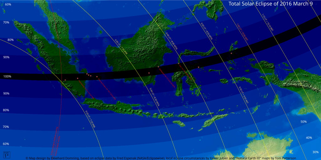
English: Local map of Indonesia, showing the Solar eclipse of March 9, 2016
Deutsch: Karte von Indonesien, den zentralen Teil der Sonnenfinsternis vom 9. März 2016 enthaltend |
| Date | |
| Source | Own work Map design by Ekkehard Domning, based on eclipse data by Fred Espenak (NASA/Eclipsewise), local eclipse circumstances by Xavier Jubier and "Natural Earth III" maps by Tom Patterson |
| Author | EkkehardDomning |
Licensing[edit]
I, the copyright holder of this work, hereby publish it under the following license:
This file is licensed under the Creative Commons Attribution-Share Alike 4.0 International license.
- You are free:
- to share – to copy, distribute and transmit the work
- to remix – to adapt the work
- Under the following conditions:
- attribution – You must give appropriate credit, provide a link to the license, and indicate if changes were made. You may do so in any reasonable manner, but not in any way that suggests the licensor endorses you or your use.
- share alike – If you remix, transform, or build upon the material, you must distribute your contributions under the same or compatible license as the original.
| This work has been released into the public domain by its author, Natural Earth. This applies worldwide. In some countries this may not be legally possible; if so: Natural Earth grants anyone the right to use this work for any purpose, without any conditions, unless such conditions are required by law.
|
File history
Click on a date/time to view the file as it appeared at that time.
| Date/Time | Thumbnail | Dimensions | User | Comment | |
|---|---|---|---|---|---|
| current | 20:10, 19 November 2015 | | 2,160 × 1,080 (1.74 MB) | EkkehardDomning (talk | contribs) | Typo UTC chonged into UT |
| 16:32, 18 November 2015 |  | 2,160 × 1,080 (1.74 MB) | EkkehardDomning (talk | contribs) | {{Information |Description ={{en|1=Local map of Indonesia, showing the Solar eclipse of March 9, 2016}} {{de|1=Karte von Indonesien, den zentralen Teil der Sonnenfinsternis vom 9. März 2016 enthaltend}} |Source ={{own}} |Author =[[U... |
You cannot overwrite this file.
File usage on Commons
The following page uses this file:
File usage on other wikis
The following other wikis use this file:
- Usage on de.wikipedia.org