File:SCatarina Island map 1776.jpg
Jump to navigation
Jump to search

Size of this preview: 800 × 493 pixels. Other resolutions: 320 × 197 pixels | 640 × 394 pixels | 1,024 × 630 pixels | 1,600 × 985 pixels.
Original file (1,600 × 985 pixels, file size: 1.38 MB, MIME type: image/jpeg)
Captions
Captions
Add a one-line explanation of what this file represents
| Description |
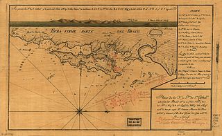
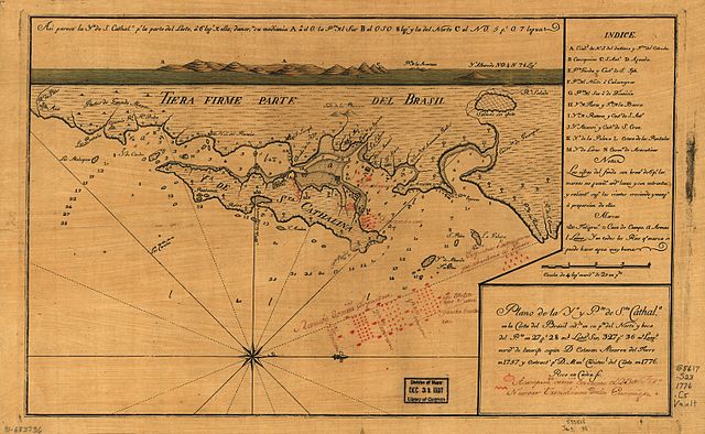
Português: Mapa da Ilha de Santa Cantarina e região próxima em espanhol, publicado em 1776, ano em que a ilha foi invadida por tropas espanholas. Local de desembarque das tropas é marcado com cor vermelha.
English: Map of Santa Catarina Island published in 1776, by Manl Christovl. del Canto.
Plano de la Ya. y Pto. de Sta. Cathala. en la costa del Brasil sitdo. en su pta. del norte y boca del pto. en 27 gs. 28 ms. latitd. sur, 327 gs. 36 ms. longd., merido. de Tenerife / según D. Estevan Alvarez del Fierro en 1757 y extracto. pr. D. Manl. Christovl. del Canto en 1776 ; Rico en Cádiz sc. |
| Date | |
| Source | http://memory.loc.gov/. |
| Author | Manl. Christovl. del Canto |

|
This map is available from the United States Library of Congress's Geography & Map Division
under the digital ID g5617s.ct000052. This tag does not indicate the copyright status of the attached work. A normal copyright tag is still required. See Commons:Licensing.
|
|
This work is in the public domain in its country of origin and other countries and areas where the copyright term is the author's life plus 100 years or fewer. | |
| This file has been identified as being free of known restrictions under copyright law, including all related and neighboring rights. | |
File history
Click on a date/time to view the file as it appeared at that time.
| Date/Time | Thumbnail | Dimensions | User | Comment | |
|---|---|---|---|---|---|
| current | 02:59, 17 October 2006 | | 1,600 × 985 (1.38 MB) | Dpc01 (talk | contribs) | {{Information |Description= {{pt|Mapa da pt:Ilha de Santa Cantarina e região próxima em espanhol, publicado em 1776, ano em que a ilha foi invadida por tropas espanholas. Local de desembarque das tropas é marcado com cor vermelha.}} {{en|Map of |
You cannot overwrite this file.
File usage on Commons
There are no pages that use this file.
File usage on other wikis
The following other wikis use this file:
- Usage on fr.wikipedia.org
- Usage on hr.wikipedia.org
- Usage on pt.wikipedia.org
- Usage on sh.wikipedia.org
- Usage on sr.wikipedia.org