File:Rubin Observatory Operations (rubin-Sites and Data Flows Map).jpg
Jump to navigation
Jump to search

Size of this preview: 800 × 486 pixels. Other resolutions: 320 × 194 pixels | 640 × 388 pixels | 1,024 × 622 pixels | 1,280 × 777 pixels | 3,000 × 1,821 pixels.
Original file (3,000 × 1,821 pixels, file size: 441 KB, MIME type: image/jpeg)
Captions
Captions
Add a one-line explanation of what this file represents
Summary[edit]
| Description |
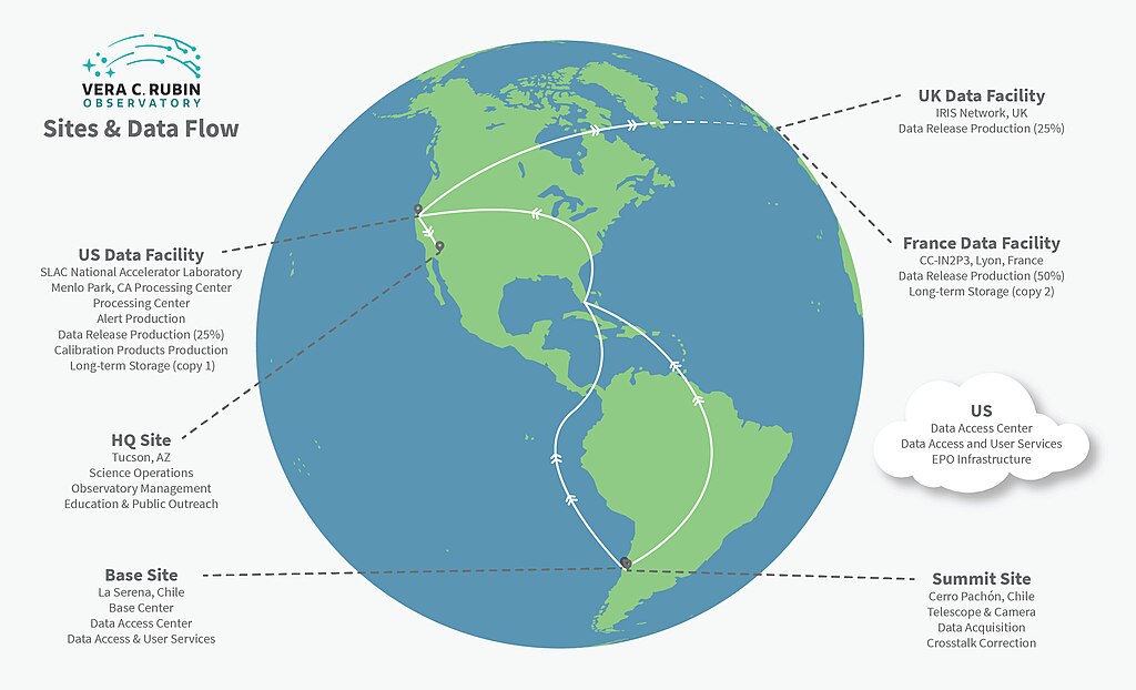
English: This graphic illustrates data flow between multiple sites during Rubin Operations.The Data Management System begins at the data acquisition interface between camera and telescope subsystems and flows through to the data products accessed by end users. On the way, it moves through three types of managed facilities supporting data management, as well as end user sites that may conduct science using LSST data or pipeline resources on their own computing infrastructure. |
| Date | 7 April 2023, 15:44 (upload date) |
| Source | Rubin Observatory Operations |
| Author | Rubin Observatory/NOIRLab/NSF/AURA |
| Other versions |
|

.jpg&action=edit§ion=1)
Licensing[edit]
.jpg&action=edit§ion=2)
This media was created by the National Optical-Infrared Astronomy Research Laboratory (NOIRLab).
Their website states: "Unless specifically noted, the images, videos, and music distributed on the public NOIRLab website, along with the texts of press releases, announcements, images of the week and captions; are licensed under a Creative Commons Attribution 4.0 International License, and may on a non-exclusive basis be reproduced without fee provided the credit is clear and visible." To the uploader: You must provide a link (URL) to the original file and the authorship information if available. | |
This file is licensed under the Creative Commons Attribution 4.0 International license.
| |
File history
Click on a date/time to view the file as it appeared at that time.
| Date/Time | Thumbnail | Dimensions | User | Comment | |
|---|---|---|---|---|---|
| current | 17:29, 13 April 2023 | | 3,000 × 1,821 (441 KB) | OptimusPrimeBot (talk | contribs) | #Spacemedia - Upload of https://noirlab.edu/public/media/archives/images/large/rubin-Sites_and_Data_Flows_Map.jpg via Commons:Spacemedia |
You cannot overwrite this file.
File usage on Commons
The following page uses this file:
.jpg&oldid=805603164)