File:River Nile map it.svg
Jump to navigation
Jump to search

Size of this PNG preview of this SVG file: 475 × 599 pixels. Other resolutions: 190 × 240 pixels | 381 × 480 pixels | 609 × 768 pixels | 812 × 1,024 pixels | 1,624 × 2,048 pixels | 636 × 802 pixels.
Original file (SVG file, nominally 636 × 802 pixels, file size: 137 KB)
Captions
Captions
Add a one-line explanation of what this file represents
Summary
[edit]
| Description |
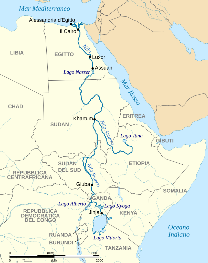
Deutsch: Verlauf des Nil mit den Quellflüssen Weißer und Blauer Nil. English: Map of the River Nile with White and Blue Nile. Italiano: Mappa del fiume Nilo, con Nilo Bianco e Nilo Azzurro. |
||
| Date | (UTC) | ||
| Source |
This file was derived from: River Nile map de.svg:  |
||
| Author |
|
| This is a retouched picture, which means that it has been digitally altered from its original version. Modifications: italian. The original can be viewed here: River Nile map de.svg:
|
Licensing
[edit]
I, the copyright holder of this work, hereby publish it under the following licenses:
This file is licensed under the Creative Commons Attribution-Share Alike 4.0 International license.
- You are free:
- to share – to copy, distribute and transmit the work
- to remix – to adapt the work
- Under the following conditions:
- attribution – You must give appropriate credit, provide a link to the license, and indicate if changes were made. You may do so in any reasonable manner, but not in any way that suggests the licensor endorses you or your use.
- share alike – If you remix, transform, or build upon the material, you must distribute your contributions under the same or compatible license as the original.

|
Permission is granted to copy, distribute and/or modify this document under the terms of the GNU Free Documentation License, Version 1.2 or any later version published by the Free Software Foundation; with no Invariant Sections, no Front-Cover Texts, and no Back-Cover Texts. A copy of the license is included in the section entitled GNU Free Documentation License. |
You may select the license of your choice.
Original upload log
[edit]
This image is a derivative work of the following images:
- File:River Nile map de.svg licensed with Cc-by-sa-4.0, GFDL
- 2020-07-05T10:35:22Z Furfur 636x802 (132904 Bytes) Details
- 2020-07-05T10:17:12Z Furfur 636x802 (132744 Bytes) Schriftgrößen
- 2020-07-05T10:03:01Z Furfur 636x802 (132772 Bytes) == {{int:filedesc}} == {{Information |Description={{User:Medium69/Traduction}} {{de|1=Verlauf des Nil mit den Quellflüssen Weißer und Blauer Nil.}} {{en|1=Map of the River Nile with White and Blue Nile.}} |Source={{Derived
Uploaded with derivativeFX
File history
Click on a date/time to view the file as it appeared at that time.
| Date/Time | Thumbnail | Dimensions | User | Comment | |
|---|---|---|---|---|---|
| current | 14:33, 22 January 2023 | | 636 × 802 (137 KB) | Arrow303 (talk | contribs) | == {{int:filedesc}} == {{Information |Description={{User:Medium69/Traduction}} {{de|1=Verlauf des Nil mit den Quellflüssen Weißer und Blauer Nil.}} {{en|1=Map of the River Nile with White and Blue Nile.}} {{it|1=Mappa del fiume Nilo, con Nilo Bianco e Nilo Azzurro.}} |Source={{Derived from|River Nile map de.svg|display=50}} |Date=2023-01-22 14:31 (UTC) |Author=* File:River Nile map de.svg: * River Nile map.svg: {{U|Hel-hama}} *this... |
You cannot overwrite this file.
File usage on Commons
The following 3 pages use this file:
File usage on other wikis
The following other wikis use this file:
- Usage on it.wikipedia.org