File:River Mole Map.png
Jump to navigation
Jump to search
No higher resolution available.
River_Mole_Map.png (447 × 544 pixels, file size: 67 KB, MIME type: image/png)
Captions
Captions
Add a one-line explanation of what this file represents
Summary
[edit]
| Description |
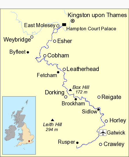
English: Map of River Mole in south east England showing part of the River Thames. Data from Open Street Maps. |
| Date | |
| Source | Own work |
| Author | Mertbiol |
| Other versions | River Mole Map.svg |
Licensing
[edit]
| I, the copyright holder of this work, release this work into the public domain. This applies worldwide. In some countries this may not be legally possible; if so: I grant anyone the right to use this work for any purpose, without any conditions, unless such conditions are required by law. |
File history
Click on a date/time to view the file as it appeared at that time.
| Date/Time | Thumbnail | Dimensions | User | Comment | |
|---|---|---|---|---|---|
| current | 14:25, 8 October 2010 | | 447 × 544 (67 KB) | Mertbiol (talk | contribs) | Sort out colouring and make rivers bolder. |
| 15:18, 17 February 2010 |  | 447 × 544 (67 KB) | Mertbiol (talk | contribs) | Add Leith Hill and Box Hill. | |
| 13:22, 17 February 2010 |  | 447 × 544 (62 KB) | Mertbiol (talk | contribs) | Make UK map smaller and tweak town/village label positions. | |
| 12:30, 17 February 2010 |  | 447 × 544 (65 KB) | Mertbiol (talk | contribs) | Sort out grey area at top for correct display in infobox | |
| 11:55, 17 February 2010 |  | 447 × 544 (65 KB) | Mertbiol (talk | contribs) | Change text sizes to fit info box better. | |
| 19:41, 14 February 2010 |  | 447 × 514 (68 KB) | Mertbiol (talk | contribs) | Smarten up border and general minor tweaks. | |
| 17:52, 14 February 2010 |  | 450 × 515 (68 KB) | Mertbiol (talk | contribs) | Add border and put Weybridge and Byfleet on map. | |
| 16:09, 14 February 2010 |  | 450 × 515 (62 KB) | Mertbiol (talk | contribs) | Add Horley to map | |
| 15:51, 14 February 2010 |  | 450 × 515 (60 KB) | Mertbiol (talk | contribs) | {{Information |Description={{en|1=Map of River Mole in south east England showing part of the River Thames}} |Source={{own}} |Author=Mertbiol |Date=2010-02-14 |Permission= |other_versions=River Mole Map.svg }} Category:Surrey |
You cannot overwrite this file.
File usage on Commons
There are no pages that use this file.
File usage on other wikis
The following other wikis use this file:
- Usage on en.wikipedia.org
- Usage on fi.wikipedia.org
- Usage on fr.wikipedia.org
- Usage on nn.wikipedia.org
- Usage on no.wikipedia.org