File:Republic of Peru 1824- 1836 (orthographic proyection).JPG
Jump to navigation
Jump to search

Size of this preview: 600 × 600 pixels. Other resolutions: 240 × 240 pixels | 480 × 480 pixels | 768 × 768 pixels | 1,024 × 1,024 pixels | 2,000 × 2,000 pixels.
Original file (2,000 × 2,000 pixels, file size: 243 KB, MIME type: image/jpeg)
Captions
Captions
Add a one-line explanation of what this file represents
| Description |
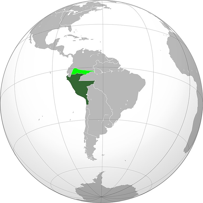
English: Location of the Republic of Peru in orthographic projection, 1824–1836. Sovereign territory. Territories claimed by the Gran Colombia. Español: Ubicación geográfica de la República del Perú en proyección ortográfica, 1824-1836. Territorio soberano. Territorios reclamados por la Gran Colombia. |
| Date | (UTC) |
| Source |
.svg) |
| Author |
|
| Other versions |
.png) |
| This is a retouched picture, which means that it has been digitally altered from its original version. The original can be viewed here: Viceroyalty of Peru (orthographic projection).svg:
|
I, the copyright holder of this work, hereby publish it under the following license:
This file is licensed under the Creative Commons Attribution 3.0 Unported license.
- You are free:
- to share – to copy, distribute and transmit the work
- to remix – to adapt the work
- Under the following conditions:
- attribution – You must give appropriate credit, provide a link to the license, and indicate if changes were made. You may do so in any reasonable manner, but not in any way that suggests the licensor endorses you or your use.
Original upload log
[edit].JPG&action=edit§ion=1)
This image is a derivative work of the following images:
- File:Viceroyalty_of_Peru_(orthographic_projection).svg licensed with Cc-by-3.0
- 2010-06-20T23:19:54Z B1mbo 550x550 (142651 Bytes) Corrected borders and included Chilean claims
- 2010-01-21T02:01:23Z Keepscases 550x550 (536032 Bytes) {{Information |Description={{en|1=Viceroyalty of Peru (orthographic projection) [http://media-2.web.britannica.com/eb-media/64/2064-004-0A19D73E.gif]}} |Source={{own}} |Author=[[User:Keepscases|Keepscases]] |Date= |Permission
Uploaded with derivativeFX
File history
Click on a date/time to view the file as it appeared at that time.
| Date/Time | Thumbnail | Dimensions | User | Comment | |
|---|---|---|---|---|---|
| current | 16:22, 8 June 2020 | | 2,000 × 2,000 (243 KB) | Marcomogollon (talk | contribs) | Faltó el territorio del Caquetá |
| 16:06, 8 June 2020 |  | 2,000 × 2,000 (241 KB) | Marcomogollon (talk | contribs) | Agrego los territorios disputados con la Gran Colombia | |
| 12:57, 29 April 2018 |  | 2,000 × 2,000 (471 KB) | Janitoalevic (talk | contribs) | Better quality | |
| 21:30, 17 November 2010 |  | 500 × 500 (22 KB) | Traleo (talk | contribs) | {{Information |Description={{en|Location of the Viceroyalty of Peru in orthographic projection, approx. 1796. {{legend|DarkGreen|Sovereign territory.}} {{legend|Lime|Territories claimed by the Captaincy General of Chile.}}}} |
You cannot overwrite this file.
File usage on Commons
The following page uses this file:
.JPG&oldid=820505132)