File:Reichskommissariat Ostland Administrative.png
Jump to navigation
Jump to search

Size of this preview: 415 × 599 pixels. Other resolutions: 166 × 240 pixels | 333 × 480 pixels | 532 × 768 pixels | 710 × 1,024 pixels | 1,420 × 2,048 pixels | 2,856 × 4,120 pixels.
Original file (2,856 × 4,120 pixels, file size: 1.89 MB, MIME type: image/png)
Captions
Captions
Add a one-line explanation of what this file represents
Summary[edit]
| Description |
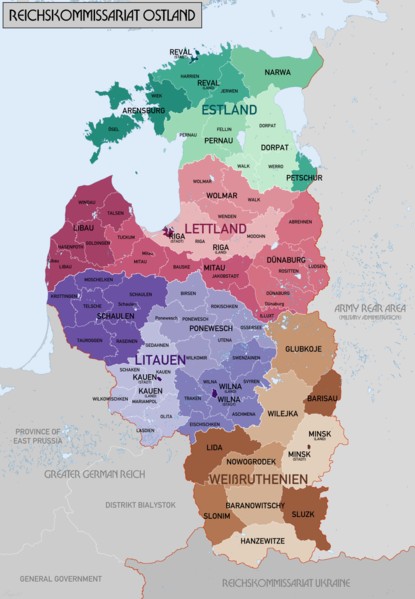
English: Administrative Map of Reichskommissariat Ostland |
| Date | |
| Source | Own work |
| Author | XrysD |
| Other versions |
Derivative works of this file: Gen Okrug Belarus Administrative.png Derivative works of this file: Generalbezirk Lettland.png |
Licensing[edit]
I, the copyright holder of this work, hereby publish it under the following licenses:

|
Permission is granted to copy, distribute and/or modify this document under the terms of the GNU Free Documentation License, Version 1.2 or any later version published by the Free Software Foundation; with no Invariant Sections, no Front-Cover Texts, and no Back-Cover Texts. A copy of the license is included in the section entitled GNU Free Documentation License. |
| This file is licensed under the Creative Commons Attribution-Share Alike 3.0 Unported license. | ||
| ||
| This licensing tag was added to this file as part of the GFDL licensing update. |
| Copyleft: This work of art is free; you can redistribute it and/or modify it according to terms of the Free Art License. You will find a specimen of this license on the Copyleft Attitude site as well as on other sites. |
You may select the license of your choice.
File history
Click on a date/time to view the file as it appeared at that time.
| Date/Time | Thumbnail | Dimensions | User | Comment | |
|---|---|---|---|---|---|
| current | 20:46, 20 February 2018 | | 2,856 × 4,120 (1.89 MB) | XrysD (talk | contribs) | Changed map colours to use ColorBrewer Wikipedia recommended palette. |
| 13:33, 20 February 2018 |  | 2,856 × 4,120 (1.86 MB) | XrysD (talk | contribs) | New version reduced legibility - e.g. borders in Riga District now invisible. | |
| 21:18, 15 February 2018 |  | 2,856 × 4,120 (2.62 MB) | 1970gemini (talk | contribs) | fiat lux | |
| 17:47, 11 May 2017 |  | 2,856 × 4,120 (1.86 MB) | XrysD (talk | contribs) | Fixed typo in source graphic and re-rendered output PNG to avoid loss of quality due to editing render rather than source. | |
| 14:58, 11 May 2017 |  | 2,856 × 4,120 (1.92 MB) | Намѣсникъ (talk | contribs) | name of Dünaburg (not Dünaberg) corrected | |
| 16:25, 22 April 2017 |  | 2,856 × 4,120 (1.71 MB) | XrysD (talk | contribs) | Added missing labels | |
| 15:54, 22 April 2017 |  | 2,856 × 4,120 (1.69 MB) | XrysD (talk | contribs) | Completely new version. Source map data: [Karte des Deutschen Reiches (Grossblatter) 1:100k, Mapa Administracyjna Rzeczypospolitej Polska 1:300k, Verwaltungskarte_Weissruthenien_u.Ssmolensk_1M_Ausg.1_(B)_X.1942, 1:500k, Strassenkarte der Baltischen Lae... | |
| 16:50, 1 September 2015 |  | 1,548 × 2,139 (1.04 MB) | Poeticbent (talk | contribs) | added missing subdivisions | |
| 22:03, 19 September 2008 |  | 1,548 × 2,139 (962 KB) | XrysD (talk | contribs) | {{Information |Description={{en|1=Administrative Map of Reichskommissariat Ostland}} |Source=Own work by uploader |Author=XrysD |Date=19/09/2008 |Permission= |other_versions= }} <!--{{ImageUpload|full}}--> |
You cannot overwrite this file.
File usage on Commons
The following 10 pages use this file:
- Atlas of Estonia
- Atlas of World War II
- User:Magog the Ogre/Maps of conflicts/2015 September
- User:Magog the Ogre/Maps of conflicts/2017 April
- User:Magog the Ogre/Maps of conflicts/2017 May
- User:Magog the Ogre/Maps of conflicts/2018 February
- File:Administrative division of Belarus (1939-1944).jpg
- File:Gen Okrug Belarus Administrative.png
- Category:Generalbezirk Estland
- Category:Stamps for the Reichskommissariat Ostland
.jpg)
File usage on other wikis
The following other wikis use this file:
- Usage on ar.wikipedia.org
- Usage on az.wikipedia.org
- Usage on be-tarask.wikipedia.org
- Usage on be.wikipedia.org
- Usage on bs.wikipedia.org
- Usage on ca.wikipedia.org
- Usage on cs.wikipedia.org
- Usage on da.wikipedia.org
- Usage on de.wikipedia.org
- Usage on en.wikipedia.org
- Reichskommissariat Ostland
- Demographic history of the Vilnius region
- Reichskommissariat
- German occupation of Lithuania during World War II
- Generalbezirk Litauen
- Wikipedia:WikiProject Military history/News/August 2012/Op-ed
- Generalbezirk Estland
- Generalbezirk Lettland
- Walther Schröder
- Karl Schäfer (SS-Brigadeführer)
- Generalbezirk Weißruthenien
- Talk:Lithuanian Territorial Defense Force/Archive 1
- Usage on es.wikipedia.org
- Usage on et.wikipedia.org
- Usage on fi.wikipedia.org
View more global usage of this file.
Metadata
Categories:
- Maps of Belarus during World War II
- Maps of World War II in Estonia
- Maps of Latvia during World War II
- Maps of Lithuania during World War II
- Maps of Poland during World War II
- Maps of Great Patriotic War
- Maps of subdivisions of Nazi Germany
- Old maps of Lithuania under Russian and German empires
- Reichskommissariat Ostland
- 1942 maps of Lithuania