File:Rail transport infrastructure map - ES - Castilla y León.svg

Original file (SVG file, nominally 1,133 × 775 pixels, file size: 5.75 MB)
Captions
Captions
Summary[edit]
| Description |
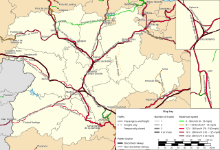
Français : Carte géographiquement exacte des infrastructures ferroviaires de Castille-et-Léon (Espagne), en 2024.
English: Geographically correct rail transport infrastructure map of Castile and Leon, as of 2024. |
| Date | |
| Source | Own work |
| Author | Benjamin Smith |
English: About represented data
|
|---|
|
This map shows all railways owned by ADIF, and those with similar characteristics (such as Perpignan-Figueres railway). It does not show local railways owned by FGC, EuskoTren, FGV and SFM, and urban rail transit such as tram or light rail lines. It does not show closed or dismantled railways either. On any particular railway section, speed limit shown on this map is the highest of all tracks, of both directions and of all types of trains allowed on this section. Although all tracks may not be electrified on multiple-track lines, a railway section is shown as electrified as long as at least one track is electrified. This map shows the official speed limits of each railway section as communicated by ADIF ; there may be smaller speed limits on some partis of the railway section. For the sake of readability, this map may take into account the total number of tracks on certain common trunks whereas these are operated as several independent lines. |
Français : Précisions sur les données représentées
|
|---|
|
Cette carte montre toutes les lignes de chemin de fer propriété du gestionnaire d'infrastructure ADIF, et celles possédant des caractéristiques équivalentes (ligne Perpigann-Figueras ...). Les lignes de tramway, métro, etc, ne sont pas représentées, de même que les lignes de caractère local exploitées par FGC, EuskoTren, FGV et SFM, les lignes fermées ou déclassées. La vitesse maximale représentée pour un tronçon de ligne est toujours celui de la voie la plus rapide, dans la direction la plus rapide, pour le type de trains le plus rapide parmi ceux autorisés sur la ligne. Une section de ligne est représentée comme électrifiée dès lors qu'au moins une voie est électrifiée. La vitesse indiquée est la vitesse nominale de la ligne communiquée par le gestionnaire d'infrastructure ; la vitesse maximale autorisée peut être plus faible en certains points, tels que la traversée des gares, les courbes, etc. Par souci de lisibilité, cette carte peut prendre en compte le nombre total de voies de certains troncs communs alors que ceux-ci sont exploités comme plusieurs lignes indépendantes. |
| Sources |
|---|
|
The information contained in this map is mainly based on: Despite all the care that has been taken in producing this map, errors may have introduced. I welcome any information that could help to correct or refine certain elements of this map. |
Licensing[edit]

|
Permission is granted to copy, distribute and/or modify this document under the terms of the GNU Free Documentation License, Version 1.2 or any later version published by the Free Software Foundation; with no Invariant Sections, no Front-Cover Texts, and no Back-Cover Texts. A copy of the license is included in the section entitled GNU Free Documentation License. |
- You are free:
- to share – to copy, distribute and transmit the work
- to remix – to adapt the work
- Under the following conditions:
- attribution – You must give appropriate credit, provide a link to the license, and indicate if changes were made. You may do so in any reasonable manner, but not in any way that suggests the licensor endorses you or your use.
- share alike – If you remix, transform, or build upon the material, you must distribute your contributions under the same or compatible license as the original.
Although this is not compulsory, I'm always glad to read that my work is useful to others. If you could send me an e-mail at benji dot wiki at gmail dot com to inform me that you are using my work, I'd be delighted. Thanks a lot!
Envie d'utiliser cette image en dehors des projets Wikimedia ? N'hésitez pas ! Cette image est placée sous licence libre de façon à ce que vous puissiez l'utiliser librement, sans avoir besoin d'une autorisation de ma part. Tout ce que vous devez faire, c'est respecter les termes de la licence et me créditer ainsi :
Bien que ce ne soit pas obligatoire, je suis toujours ravi d'apprendre que mon travail a été utile à d'autres. Si vous pouviez m'envoyer un courriel à benji point wiki arobase gmail point com pour m'informer du fait que vous utilisez mon travail, ce serait top. Merci d'avance !
File history
Click on a date/time to view the file as it appeared at that time.
| Date/Time | Thumbnail | Dimensions | User | Comment | |
|---|---|---|---|---|---|
| current | 16:46, 11 May 2024 | | 1,133 × 775 (5.75 MB) | Benjism89 (talk | contribs) | Uploaded a work by Benjamin Smith from {{own}} with UploadWizard |
You cannot overwrite this file.
File usage on Commons
The following 3 pages use this file: