File:Rail Tracks map Toyohashi Station.svg
Jump to navigation
Jump to search

Size of this PNG preview of this SVG file: 800 × 371 pixels. Other resolutions: 320 × 148 pixels | 640 × 297 pixels | 1,024 × 475 pixels | 1,280 × 593 pixels | 2,560 × 1,186 pixels | 2,104 × 975 pixels.
Original file (SVG file, nominally 2,104 × 975 pixels, file size: 530 KB)
Captions
Captions
Add a one-line explanation of what this file represents
Summary[edit]
| Description |
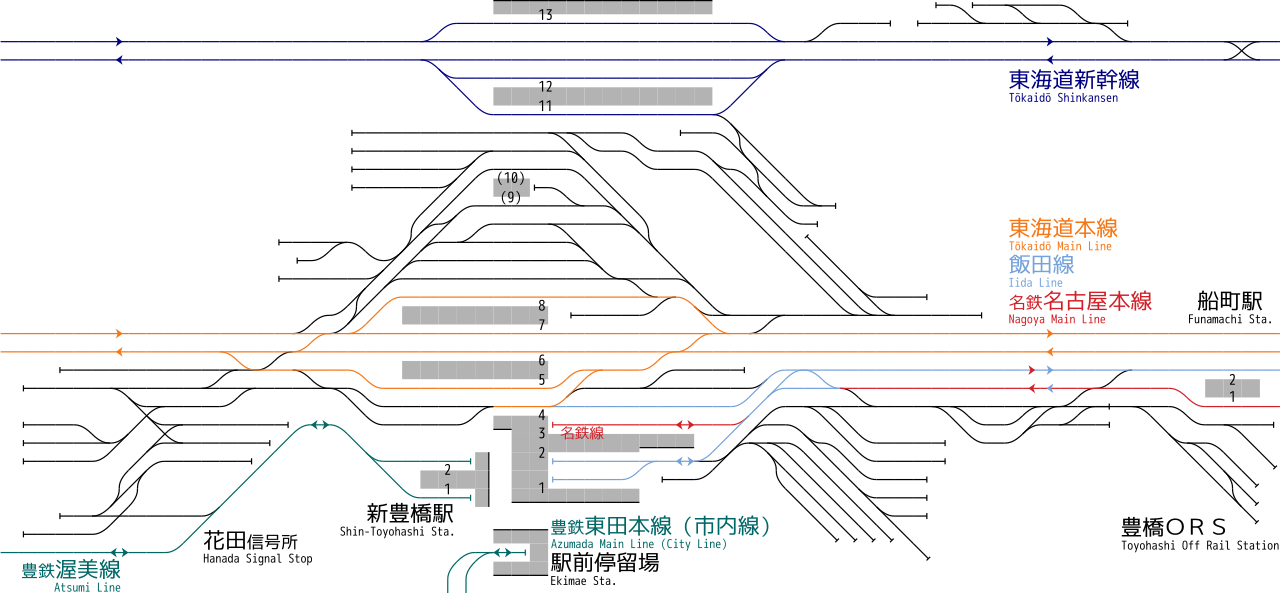
English: Rail tracks map of Central Japan Railway Company Tōkaidō Shinkansen,Tōkaidō Main Line,Iida Line and Nagoya Railroad Nagoya Main Line Toyohasi Station, and Toyohashi Railroad Atsumi Line Shin Toyohashi Station,and Toyohashi Railroad Azumada Main Line (City Line) Ekimae Station,and Japan Freight Railway Company Totohashi ORS. Reference material: Ryozo KAWASHIMA, "TOKAIDŌ LINE All lines,stations and rail tracks (ja:Zensen, Zen-eki, Zen-haisen) No.4 Toyohashi station - Nagoya Area", ISBN 978-4062700146 , pp.6-7, Kodansha, 2009-06. Created from icons in Category:Rail_tracks_map_template 日本語: JR東海 東海道新幹線・東海道線・飯田線・名古屋鉄道名古屋本線 豊橋駅/豊橋鉄道 渥美線 新豊橋駅/豊橋鉄道 東田本線(市内線) 駅前駅/JR貨物 豊橋ORS 配線図 参考文献:川島令三、『東海道ライン 全線・全駅・全配線 第4巻 豊橋駅 - 名古屋エリア』、pp.6-7, 講談社、2009年6月、ISBN 978-4062700146) 凡例は駅配線図テンプレートを参照 |
| Date | |
| Source | Own work |
| Author | ButuCC |
Licensing[edit]
I, the copyright holder of this work, hereby publish it under the following license:
This file is licensed under the Creative Commons Attribution-Share Alike 3.0 Unported license.
- You are free:
- to share – to copy, distribute and transmit the work
- to remix – to adapt the work
- Under the following conditions:
- attribution – You must give appropriate credit, provide a link to the license, and indicate if changes were made. You may do so in any reasonable manner, but not in any way that suggests the licensor endorses you or your use.
- share alike – If you remix, transform, or build upon the material, you must distribute your contributions under the same or compatible license as the original.
File history
Click on a date/time to view the file as it appeared at that time.
| Date/Time | Thumbnail | Dimensions | User | Comment | |
|---|---|---|---|---|---|
| current | 11:50, 27 February 2018 | | 2,104 × 975 (530 KB) | ButuCC (talk | contribs) | color change |
| 15:35, 1 October 2013 |  | 2,104 × 975 (541 KB) | ButuCC (talk | contribs) | amend (駅前駅→駅前停留場) | |
| 13:39, 9 December 2012 |  | 2,119 × 975 (542 KB) | ButuCC (talk | contribs) | {{Information |description={{ja|1=Rail tracks map of Central Japan Railway Company Tōkaidō Shinkansen,Tōkaidō Main Line,Iida Line and Nagoya Railroad Nagoya Main Line Toyohasi Station, and Toyohashi Railroad Atsumi Line Shin Toyohashi Station,and ... |
You cannot overwrite this file.
File usage on Commons
The following 6 pages use this file:
- User:ButuCC/Image/Rail Tracks
- User:Chumwa/OgreBot/Potential transport maps/2018 February 19-28
- User:Chumwa/OgreBot/Public transport information/2018 February 19-28
- User:Chumwa/OgreBot/Transport Maps/2018 February 19-28
- User:Chumwa/OgreBot/Travel and communication maps/2018 February 19-28
- User:콩가루/일본철도/2018 February
File usage on other wikis
The following other wikis use this file:
- Usage on de.wikipedia.org
- Usage on en.wikipedia.org
- Usage on ja.wikipedia.org
- Usage on zh.wikipedia.org