File:Réseaux ferrés en Bretagne.svg
Jump to navigation
Jump to search

Size of this PNG preview of this SVG file: 800 × 546 pixels. Other resolutions: 320 × 218 pixels | 640 × 436 pixels | 1,024 × 698 pixels | 1,280 × 873 pixels | 2,560 × 1,746 pixels | 1,044 × 712 pixels.
Original file (SVG file, nominally 1,044 × 712 pixels, file size: 41 KB)
Captions
Captions
Add a one-line explanation of what this file represents
Summary[edit]
| Description |
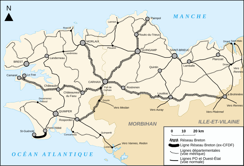
Français : Carte des réseaux ferrés en Bretagne : différents types de voies (voies étroites, etc.).
English: Map of the rail infrastructure in en:Brittany (France).
Deutsch: Karte der Eisenbahnen in der de:Bretagne (Frankreich).
Español: Mapa de las vias de tren en Bretaña (Francia).
Italiano: Mappa delle vie di treni della Bretania. |
| Date | |
| Source | Own work Signalétique : Image:Chemins de fer en Seine-Maritime.svg |
| Author | Bourrichon |
| Other versions |
|

Licensing[edit]

|
Permission is granted to copy, distribute and/or modify this document under the terms of the GNU Free Documentation License, Version 1.2 or any later version published by the Free Software Foundation; with no Invariant Sections, no Front-Cover Texts, and no Back-Cover Texts. A copy of the license is included in the section entitled GNU Free Documentation License. |
| This file is licensed under the Creative Commons Attribution-Share Alike 3.0 Unported license. | ||
| ||
| This licensing tag was added to this file as part of the GFDL licensing update. |
This file is licensed under the Creative Commons Attribution-Share Alike 3.0 Unported license.
- You are free:
- to share – to copy, distribute and transmit the work
- to remix – to adapt the work
- Under the following conditions:
- attribution – You must give appropriate credit, provide a link to the license, and indicate if changes were made. You may do so in any reasonable manner, but not in any way that suggests the licensor endorses you or your use.
- share alike – If you remix, transform, or build upon the material, you must distribute your contributions under the same or compatible license as the original.

|
This SVG file contains embedded text that can be translated into your language, using any capable SVG editor, text editor or the SVG Translate tool. For more information see: About translating SVG files. |
This W3C-unspecified vector image was created with Inkscape .
File history
Click on a date/time to view the file as it appeared at that time.
| Date/Time | Thumbnail | Dimensions | User | Comment | |
|---|---|---|---|---|---|
| current | 19:25, 14 January 2013 | | 1,044 × 712 (41 KB) | VIGNERON (talk | contribs) | optimisation |
| 19:21, 12 February 2008 |  | 1,044 × 712 (190 KB) | Ayack (talk | contribs) | {{Information |Description= |Source= |Date= |Author= |Permission= |other_versions= }} | |
| 18:38, 11 February 2008 |  | 1,044 × 712 (129 KB) | Bourrichon (talk | contribs) | + couleur des toponymes extérieurs => gris | |
| 18:22, 11 February 2008 |  | 1,044 × 712 (129 KB) | Bourrichon (talk | contribs) | + côte sud corrigée (Lorient) | |
| 12:37, 11 February 2008 |  | 1,044 × 712 (291 KB) | Bourrichon (talk | contribs) | + quelques villes | |
| 22:30, 10 February 2008 |  | 1,044 × 712 (112 KB) | Bourrichon (talk | contribs) | {{Information |Description= {{fr|Carte des réseaux ferrés en Bretagne}} {{en|}} {{de|}} {{es|}} {{it|}} |Source=travail personnel. Signalétique : Image:Chemins de fer en Seine-Maritime.svg en: |Date=10 fév 2008 |Author= [[User:Bourrichon|B |
You cannot overwrite this file.
File usage on Commons
The following page uses this file:
File usage on other wikis
The following other wikis use this file:
- Usage on de.wikipedia.org
- Usage on fr.wikipedia.org
- Usage on www.wikidata.org