File:Régence d'Alger en 1829.png
Jump to navigation
Jump to search

Size of this preview: 800 × 522 pixels. Other resolutions: 320 × 209 pixels | 640 × 417 pixels | 934 × 609 pixels.
Original file (934 × 609 pixels, file size: 897 KB, MIME type: image/png)
Captions
Captions
Add a one-line explanation of what this file represents
Summary[edit]
| Description |
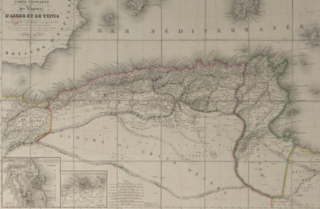
English: Carte montrant la réelle étendue géographique de la Régence d'Algérie ainsi que ses frontières précises, ses reliefs et ses villes avant le débarquement français |
| Date | |
| Source | Archives de la BNF - fichier PDF |
| Author | Pierre Marie Lapie |
Licensing[edit]
|
This work is in the public domain in its country of origin and other countries and areas where the copyright term is the author's life plus 70 years or fewer. This work is in the public domain in the United States because it was published (or registered with the U.S. Copyright Office) before January 1, 1929. | |
| This file has been identified as being free of known restrictions under copyright law, including all related and neighboring rights. | |
File history
Click on a date/time to view the file as it appeared at that time.
| Date/Time | Thumbnail | Dimensions | User | Comment | |
|---|---|---|---|---|---|
| current | 22:46, 20 June 2020 | | 934 × 609 (897 KB) | Sirroconouveau (talk | contribs) | Uploaded a work by Pierre Marie Lapie from Archives de la BNF - fichier PDF with UploadWizard |
You cannot overwrite this file.
File usage on Commons
There are no pages that use this file.
File usage on other wikis
The following other wikis use this file:
- Usage on en.wikipedia.org