File:Queen of the Sea rail disaster - Peraliya- map.jpg
Jump to navigation
Jump to search
No higher resolution available.
Queen_of_the_Sea_rail_disaster_-_Peraliya-_map.jpg (334 × 373 pixels, file size: 30 KB, MIME type: image/jpeg)
Captions
Captions
Add a one-line explanation of what this file represents


Summary
[edit]
| Description |
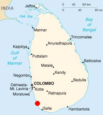
English: Map, locating the Queen of the Sea rail disaster in Peraliya Sri Lanka
Deutsch: Karte, zeigt den Queen of the Sea rail Unglücksort in Peraliya Sri Lanka |
| Date | |
| Source | http://maps.mygeo.info/cont/landkarten/2001/Landkarte_Sri_Lanka_2001.jpg |
| Author | CIA Factbook |
Licensing
[edit]
This work is in the public domain in the United States because it is a work prepared by an officer or employee of the United States Government as part of that person’s official duties under the terms of Title 17, Chapter 1, Section 105 of the US Code.
Note: This only applies to original works of the Federal Government and not to the work of any individual U.S. state, territory, commonwealth, county, municipality, or any other subdivision. This template also does not apply to postage stamp designs published by the United States Postal Service since 1978. (See § 313.6(C)(1) of Compendium of U.S. Copyright Office Practices). It also does not apply to certain US coins; see The US Mint Terms of Use.
|
 | |
| This file has been identified as being free of known restrictions under copyright law, including all related and neighboring rights. | ||
File history
Click on a date/time to view the file as it appeared at that time.
| Date/Time | Thumbnail | Dimensions | User | Comment | |
|---|---|---|---|---|---|
| current | 12:32, 30 August 2009 | | 334 × 373 (30 KB) | Smartbyte (talk | contribs) | {{Information |Description={{en|1=Map, locating the Queen of the Sea rail disaster in Peraliya Sri Lanka}} {{de|1=Karte, zeigt den Queen of the Sea rail Unglücksort in Peraliya Sri Lanka}} |Source=http://maps.mygeo.info/cont/landkarten/2001/Landkarte_Sri |
You cannot overwrite this file.
File usage on Commons
There are no pages that use this file.
File usage on other wikis
The following other wikis use this file:
- Usage on cs.wikipedia.org
- Usage on de.wikipedia.org
- Usage on fr.wikipedia.org
- Usage on it.wikipedia.org
- Usage on nl.wikipedia.org
- Usage on ru.wikipedia.org
- Usage on si.wikipedia.org