File:Putz119.jpg
Jump to navigation
Jump to search

Size of this preview: 357 × 600 pixels. Other resolutions: 143 × 240 pixels | 476 × 800 pixels.
Original file (476 × 800 pixels, file size: 136 KB, MIME type: image/jpeg)
Captions
Captions
Add a one-line explanation of what this file represents
Summary
[edit]
| Description |
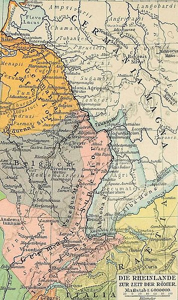
English: Map of the Rhineland, Germanic tribes, antiquity, Roman Empire |
| Date | Drawn in 1903, uploaded in 2022 |
| Source |
F.W. Putzgers historischer schul-atlas zur alten, mittleren und neuen Geschichte : in 234 haupt- und nebenkarten https://archive.org/details/fwputzgershistor00putz_0 |
| Author | Drawn by F. W. Putzger, A. Baldamus and E. Schwabe, uploaded to Wikimedia Commons by User:Gyalu22 |
Licensing
[edit]
This file is licensed under the Creative Commons Attribution-Share Alike 4.0 International license.
- You are free:
- to share – to copy, distribute and transmit the work
- to remix – to adapt the work
- Under the following conditions:
- attribution – You must give appropriate credit, provide a link to the license, and indicate if changes were made. You may do so in any reasonable manner, but not in any way that suggests the licensor endorses you or your use.
- share alike – If you remix, transform, or build upon the material, you must distribute your contributions under the same or compatible license as the original.
File history
Click on a date/time to view the file as it appeared at that time.
| Date/Time | Thumbnail | Dimensions | User | Comment | |
|---|---|---|---|---|---|
| current | 18:08, 9 December 2022 | | 476 × 800 (136 KB) | Gyalu22 (talk | contribs) | Uploaded a work by Drawn by F. W. Putzger, A. Baldamus and E. Schwabe, uploaded to Wikimedia Commons by User:Gyalu22 from F.W. Putzgers historischer schul-atlas zur alten, mittleren und neuen Geschichte : in 234 haupt- und nebenkarten https://archive.org/details/fwputzgershistor00putz_0 with UploadWizard |
You cannot overwrite this file.
File usage on Commons
There are no pages that use this file.
File usage on other wikis
The following other wikis use this file: