File:Prussiamap-es.svg
Jump to navigation
Jump to search

Size of this PNG preview of this SVG file: 715 × 599 pixels. Other resolutions: 286 × 240 pixels | 573 × 480 pixels | 916 × 768 pixels | 1,222 × 1,024 pixels | 2,444 × 2,048 pixels | 976 × 818 pixels.
Original file (SVG file, nominally 976 × 818 pixels, file size: 879 KB)
Captions
Captions
Add a one-line explanation of what this file represents
Summary[edit]
| Description |
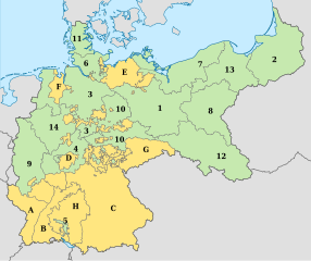
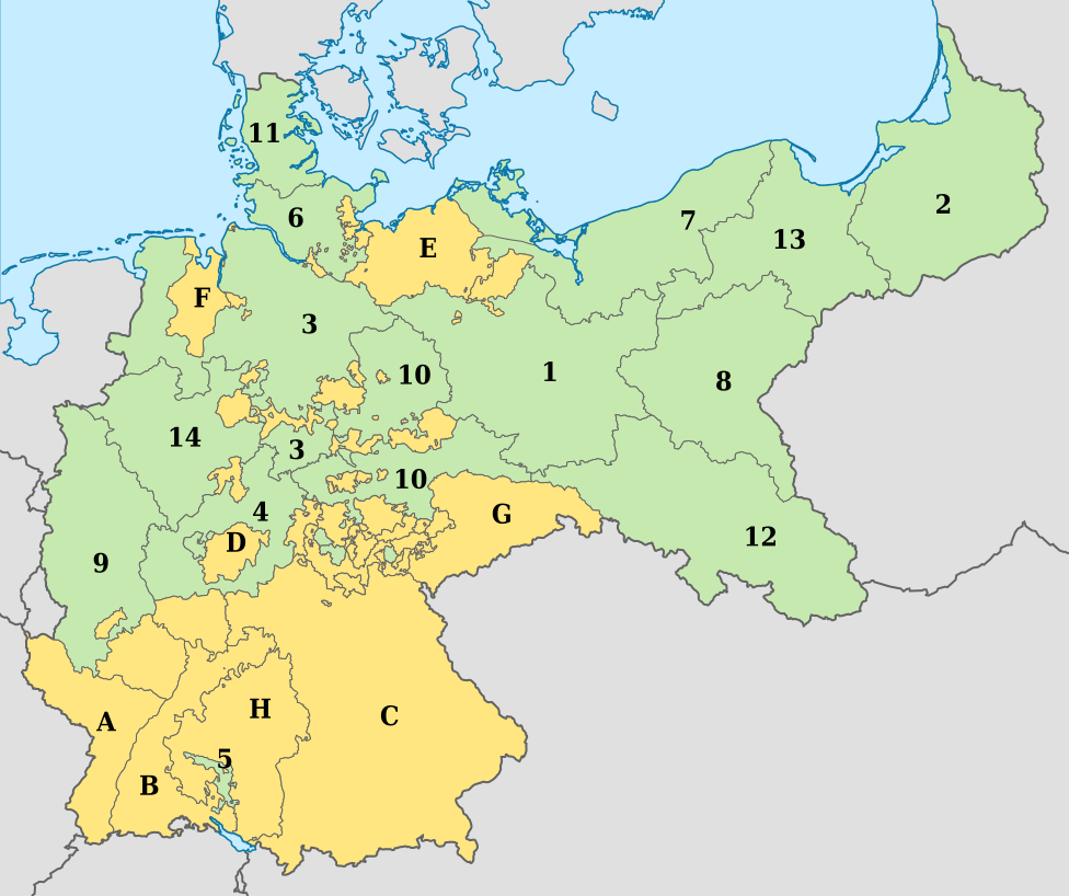
English: Prussia in the German Empire (1871-1918).
Español: Prusia en el Imperio alemán (1871-1918).
Territorios prusianos: 1.-Brandeburgo 2.-Prusia oriental 3.-Hanóver 4.-Hesse-Nassau 5.-Hohenzollern 6.-Holstein 7.-Pomerania 8.-Posen 9.-Sajonia 10.-Sajonia 11.-Schweswig 12.-Silesia 13.-Prusia occidental 14.-Westfalia Otros territorios del imperio: A: Alsacia-Lorena B: Baden C: Baviera D: Hesse E: Mecklemburgo F. Oldemburgo G: Sajonia H: Wurtemberg Leyenda: Prusia.
Otros estados del Imperio alémán. |
| Source |
This file was derived from: Prussiamap.gif |
| Author | Adam Carr |
| Other versions |
 |
Licensing[edit]
This file is licensed under the Creative Commons Attribution-Share Alike 3.0 Unported license.
- You are free:
- to share – to copy, distribute and transmit the work
- to remix – to adapt the work
- Under the following conditions:
- attribution – You must give appropriate credit, provide a link to the license, and indicate if changes were made. You may do so in any reasonable manner, but not in any way that suggests the licensor endorses you or your use.
- share alike – If you remix, transform, or build upon the material, you must distribute your contributions under the same or compatible license as the original.
File history
Click on a date/time to view the file as it appeared at that time.
| Date/Time | Thumbnail | Dimensions | User | Comment | |
|---|---|---|---|---|---|
| current | 10:15, 13 April 2019 | | 976 × 818 (879 KB) | Rowanwindwhistler (talk | contribs) | Uploading a file from a free published source using File Upload Wizard |
You cannot overwrite this file.
File usage on Commons
There are no pages that use this file.
File usage on other wikis
The following other wikis use this file:
- Usage on en.wikipedia.org
- Usage on es.wikipedia.org