File:Provincia de Tacna-1895.jpg
Original file (3,086 × 4,535 pixels, file size: 9.19 MB, MIME type: image/jpeg)
Captions
Captions
Summary[edit]
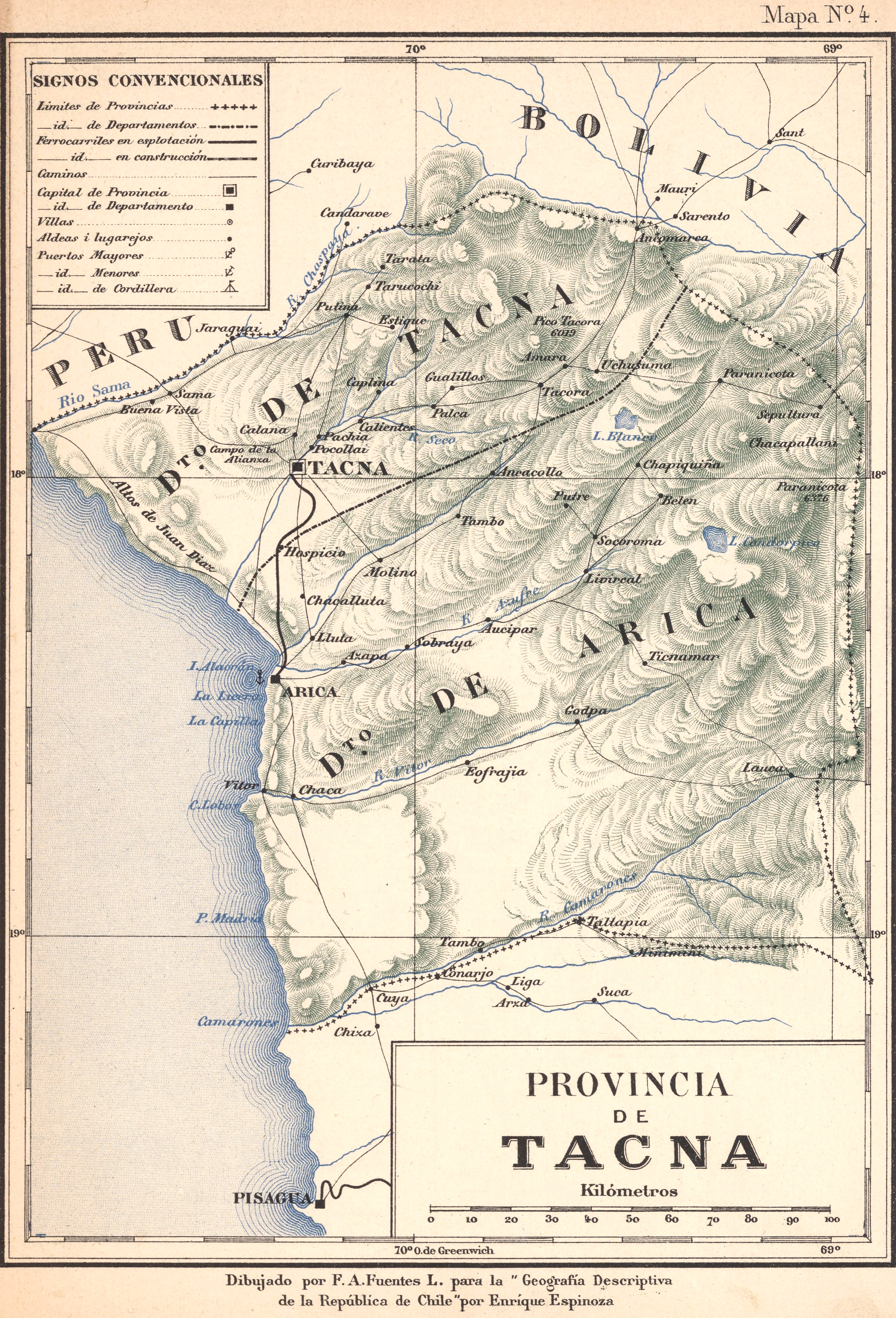
| Description | Mapa de la antigua Provincia chilena de Tacna, hacia 1895, que se dividía en los Departamentos de Tacna y Arica, actuales Provincia de Tacna y Tarata, Departamento de Tacna (Perú) y Provincia de Arica y Parinacota, XV Región de Arica y Parinacota (Chile) |
| Date | |
| Source | Jeografía descriptiva de la República de Chile: arreglada según las últimas divisiones administrativas, las más recientes esploraciones i en conformidad al censo jeneral de la República levantado el 28 de noviembre de 1895, por Enrique Espinoza. Cuarta edición, considerablemente aumentada. Santiago de Chile: Imprenta i Encuadernación Barcelona, 1897. |
| Author | F. A. Fuentes |
| Permission (Reusing this file) |
PD |
Licensing[edit]
|
This is a faithful photographic reproduction of a two-dimensional, public domain work of art. The work of art itself is in the public domain for the following reason:
The official position taken by the Wikimedia Foundation is that "faithful reproductions of two-dimensional public domain works of art are public domain". This photographic reproduction is therefore also considered to be in the public domain in the United States. In other jurisdictions, re-use of this content may be restricted; see Reuse of PD-Art photographs for details. {{PD-Art}} template without license parameter: please specify why the underlying work is public domain in both the source country and the United States
(Usage: {{PD-Art|1=|deathyear=''year of author's death''|country=''source country''}}, where parameter 1= can be PD-old-auto, PD-old-auto-expired, PD-old-auto-1996, PD-old-100 or similar. See Commons:Multi-license copyright tags for more information.) | ||||
File history
Click on a date/time to view the file as it appeared at that time.
| Date/Time | Thumbnail | Dimensions | User | Comment | |
|---|---|---|---|---|---|
| current | 19:06, 1 August 2015 | | 3,086 × 4,535 (9.19 MB) | Janitoalevic (talk | contribs) | Archivo de Mayor Resolución. |
| 19:05, 1 August 2015 |  | 3,086 × 4,535 (9.19 MB) | Janitoalevic (talk | contribs) | Archivo de Mayor Resolución. | |
| 03:22, 23 February 2007 |  | 692 × 1,007 (137 KB) | Yakoo (talk | contribs) | ||
| 03:17, 23 February 2007 |  | 694 × 1,007 (138 KB) | Yakoo (talk | contribs) | {{Information |Description = Mapa de la antigua Provincia de Tacna de Chile, hacia 1895, que incluía los Departamentos de Tacna y Arica, actuales Departamento de Tacna (Perú) y [[w:es:Provincia de Arica|Provincia d |
You cannot overwrite this file.
File usage on Commons
The following page uses this file:
File usage on other wikis
The following other wikis use this file:
- Usage on en.wikipedia.org
- Usage on es.wikipedia.org
- Usage on ru.wikipedia.org