File:Princes Risborough, The Pudding Stone - geograph.org.uk - 747364.jpg
Jump to navigation
Jump to search
No higher resolution available.
Princes_Risborough,_The_Pudding_Stone_-_geograph.org.uk_-_747364.jpg (640 × 480 pixels, file size: 121 KB, MIME type: image/jpeg)
Captions
Captions
Add a one-line explanation of what this file represents
Summary[edit]
| Description |
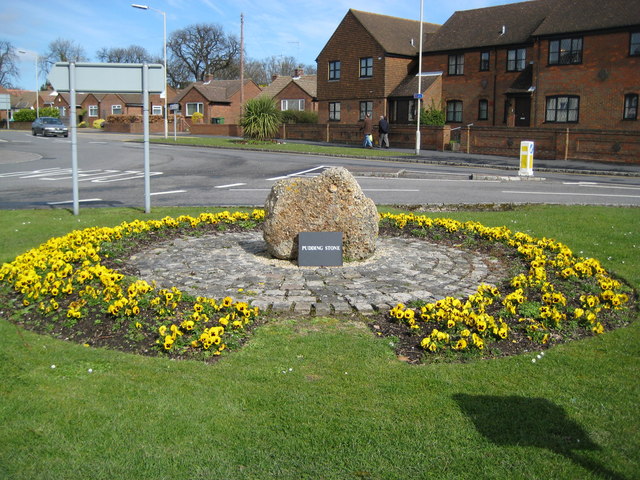
English: Princes Risborough: The Pudding Stone The pudding stone is seen here, set in setts, and surrounded by a sea of yellow pansies, on the south-east side of the roundabout at the junction of Bell Street and New Road.
The Princes Risborough Area Heritage Society plaque nearby describes it thus: "Puddingstone boulders such as this are thought to have been used as way-markers by prehistoric man, and this one stood in Back Lane, though latterly largely unobserved and buried for all but a few inches. It was moved to its present prominent position when the lane was widened in 1984. Puddingstone is one form of what is generally called 'sarsen'. Laid down some 50 million years ago, when this region had a hot tropical climate, as a layer over the chalk known as silcrete, it was broken into blocks by the freeze-thaw action of the Ice Age less than 2 million years ago, and these blocks were then carried into the valleys by the torrent of melt-water. Most of the setts surrounding the Puddingstone are of a finer grained sarsen, quarried locally at Denner Hill. Once widely used as paving in the town few of these attractive buff stones survive but some may be seen in their original setting under the Market House." |
| Date | |
| Source | From geograph.org.uk |
| Author | Nigel Cox |
| Attribution (required by the license) | Nigel Cox / Princes Risborough: The Pudding Stone / |
| Camera location | | View this and other nearby images on: OpenStreetMap |
|---|
_heading:0.00&language=en)
| Object location | | View this and other nearby images on: OpenStreetMap |
|---|
_heading:0.00&language=en)
Licensing[edit]

|
This image was taken from the Geograph project collection. See this photograph's page on the Geograph website for the photographer's contact details. The copyright on this image is owned by Nigel Cox and is licensed for reuse under the Creative Commons Attribution-ShareAlike 2.0 license.
|
This file is licensed under the Creative Commons Attribution-Share Alike 2.0 Generic license.
Attribution: Nigel Cox
- You are free:
- to share – to copy, distribute and transmit the work
- to remix – to adapt the work
- Under the following conditions:
- attribution – You must give appropriate credit, provide a link to the license, and indicate if changes were made. You may do so in any reasonable manner, but not in any way that suggests the licensor endorses you or your use.
- share alike – If you remix, transform, or build upon the material, you must distribute your contributions under the same or compatible license as the original.
File history
Click on a date/time to view the file as it appeared at that time.
| Date/Time | Thumbnail | Dimensions | User | Comment | |
|---|---|---|---|---|---|
| current | 12:18, 19 February 2011 | | 640 × 480 (121 KB) | GeographBot (talk | contribs) | == {{int:filedesc}} == {{Information |description={{en|1=Princes Risborough: The Pudding Stone The pudding stone is seen here, set in setts, and surrounded by a sea of yellow pansies, on the south-east side of the roundabout at the junction of Bell Street |
You cannot overwrite this file.
File usage on Commons
There are no pages that use this file.