File:Pradawne i pierwotne lasy bukowe Karpat i innych regionów Europy - mapa.jpg
Jump to navigation
Jump to search

Size of this preview: 737 × 600 pixels. Other resolutions: 295 × 240 pixels | 590 × 480 pixels.
Original file (800 × 651 pixels, file size: 125 KB, MIME type: image/jpeg)
Captions
Captions
Add a one-line explanation of what this file represents
Summary[edit]
| Description |
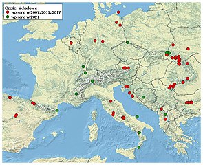
Polski: Obszary (części składowe, component parts) obiektu światowego dziedzictwa UNESCO "Pradawne i pierwotne lasy bukowe Karpat i innych regionów Europy" ("Ancient and Primeval Beech Forests of the Carpathians and Other Regions of Europe"). Kolory:
|
| Date | |
| Source |
Own work using: współrzędne geograficzne dostępne w materiałach UNESCO WH (http://whc.unesco.org/en/list/1133)
|
| Author | Darekk2 z wykorzystaniem współrzędnych geograficznych dostępnych w materiałach UNESCO WH (http://whc.unesco.org/en/list/1133) |
Licensing[edit]
I, the copyright holder of this work, hereby publish it under the following license:
This file is licensed under the Creative Commons Attribution-Share Alike 4.0 International license.
- You are free:
- to share – to copy, distribute and transmit the work
- to remix – to adapt the work
- Under the following conditions:
- attribution – You must give appropriate credit, provide a link to the license, and indicate if changes were made. You may do so in any reasonable manner, but not in any way that suggests the licensor endorses you or your use.
- share alike – If you remix, transform, or build upon the material, you must distribute your contributions under the same or compatible license as the original.
File history
Click on a date/time to view the file as it appeared at that time.
| Date/Time | Thumbnail | Dimensions | User | Comment | |
|---|---|---|---|---|---|
| current | 19:26, 14 August 2021 | | 800 × 651 (125 KB) | Darekk2 (talk | contribs) | corrected coordinates of Stuzhytsia – Uzhok |
| 21:17, 11 August 2021 |  | 800 × 651 (125 KB) | Darekk2 (talk | contribs) | inscribed in 2021 on the top | |
| 23:50, 5 August 2021 |  | 800 × 651 (125 KB) | Darekk2 (talk | contribs) | Uploaded own work with UploadWizard |
You cannot overwrite this file.
File usage on Commons
There are no pages that use this file.