File:Powiat policki location map.png
Jump to navigation
Jump to search
Size of this preview: 264 × 598 pixels. Other resolutions: 106 × 240 pixels | 569 × 1,289 pixels.
Original file (569 × 1,289 pixels, file size: 144 KB, MIME type: image/png)
Captions
Captions
Add a one-line explanation of what this file represents
| Description |
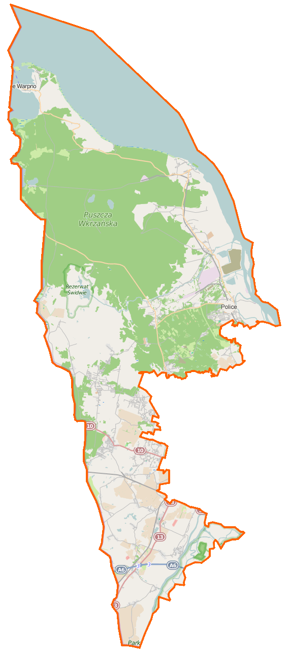
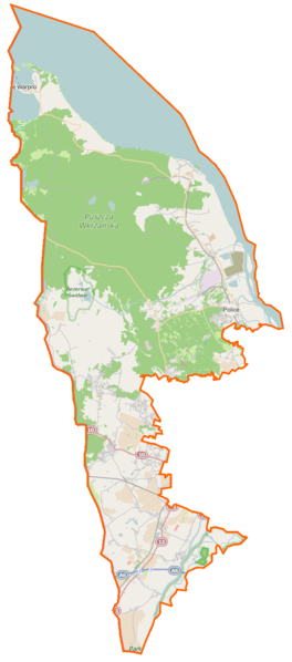
Polski: Mapa powiatu polickiego, Polska
English: Map of Powiat policki, Poland |
|||||||||
| Date | ||||||||||
| Source | You may find a page on the OpenStreetMap wiki page for Powiat policki | |||||||||
| Creator |
OpenStreetMap contributors OpenStreetMap contributors |
|||||||||
| Permission (Reusing this file) |
OpenStreetMap data is available under the Open Database License (details). Map tiles are licensed under the Creative Commons Attribution-ShareAlike 2.0 license (CC-BY-SA 2.0).
This file is licensed under the Creative Commons Attribution-Share Alike 2.0 Generic license.
|
|||||||||
| Geotemporal data | ||||||||||
| Bounding box |
|
|||||||||
| Georeferencing | If inappropriate please set warp_status = skip to hide. | |||||||||
File history
Click on a date/time to view the file as it appeared at that time.
| Date/Time | Thumbnail | Dimensions | User | Comment | |
|---|---|---|---|---|---|
| current | 06:37, 19 February 2015 | | 569 × 1,289 (144 KB) | VanWiel (talk | contribs) | {{OpenStreetMap | name = Powiat policki | location = Powiat policki | description = {{pl|Mapa powiatu polickiego, Polska}} {{en|Map of Powiat policki, Poland}} | top = 53.7942 | bottom = 53.2673 | l... |
You cannot overwrite this file.
File usage on Commons
There are no pages that use this file.
File usage on other wikis
The following other wikis use this file:
- Usage on eo.wikipedia.org
- Usage on fr.wikipedia.org
- Usage on pl.wikipedia.org
- Powiat policki
- Kołbaskowo
- Bezrzecze (powiat policki)
- Warzymice
- Wołczkowo
- Siadło Dolne
- Siadło Górne
- Buk (powiat policki)
- Dobra (powiat policki)
- Lubieszyn (Wąwelnica)
- Stobno (województwo zachodniopomorskie)
- Mierzyn (powiat policki)
- Bolków (województwo zachodniopomorskie)
- Pilchowo (powiat policki)
- Barnisław (wieś)
- Będargowo (powiat policki)
- Bobolin (powiat policki)
- Kamieniec (województwo zachodniopomorskie)
- Karwowo (powiat policki)
- Kurów (województwo zachodniopomorskie)
- Moczyły
- Ostoja (województwo zachodniopomorskie)
- Przecław (województwo zachodniopomorskie)
- Nowe Warpno
- Trzebież
- Rezerwat przyrody Świdwie
- Świdwie (jezioro)
- Stolec (województwo zachodniopomorskie)
- Stolsko
- Gunica
- Ratusz w Nowym Warpnie
- Kościół Wniebowzięcia Najświętszej Maryi Panny w Nowym Warpnie
- Kościół św. Huberta w Nowym Warpnie
- Podgrodzie (Nowe Warpno)
- Jezioro Nowowarpieńskie
- Myśliborka
- Jezioro Myśliborskie Wielkie
- Jezioro Myśliborskie Małe
- Piaski (jezioro w Puszczy Wkrzańskiej)
- Warnołęka
- Kościół Matki Bożej Częstochowskiej w Warnołęce
- Myślibórz Mały
- Myślibórz Wielki
- Mszczuje
- Łysa Wyspa
- Karszno
- Tanowo
- Brzózki (województwo zachodniopomorskie)
View more global usage of this file.