File:Poverty rates by state. US map.svg
Jump to navigation
Jump to search

Size of this PNG preview of this SVG file: 512 × 341 pixels. Other resolutions: 320 × 213 pixels | 640 × 426 pixels | 1,024 × 682 pixels | 1,280 × 853 pixels | 2,560 × 1,705 pixels.
Original file (SVG file, nominally 512 × 341 pixels, file size: 46 KB)
Captions
Captions
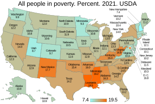
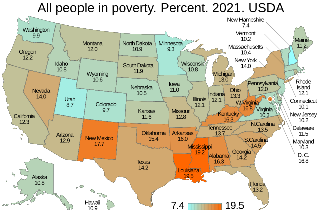
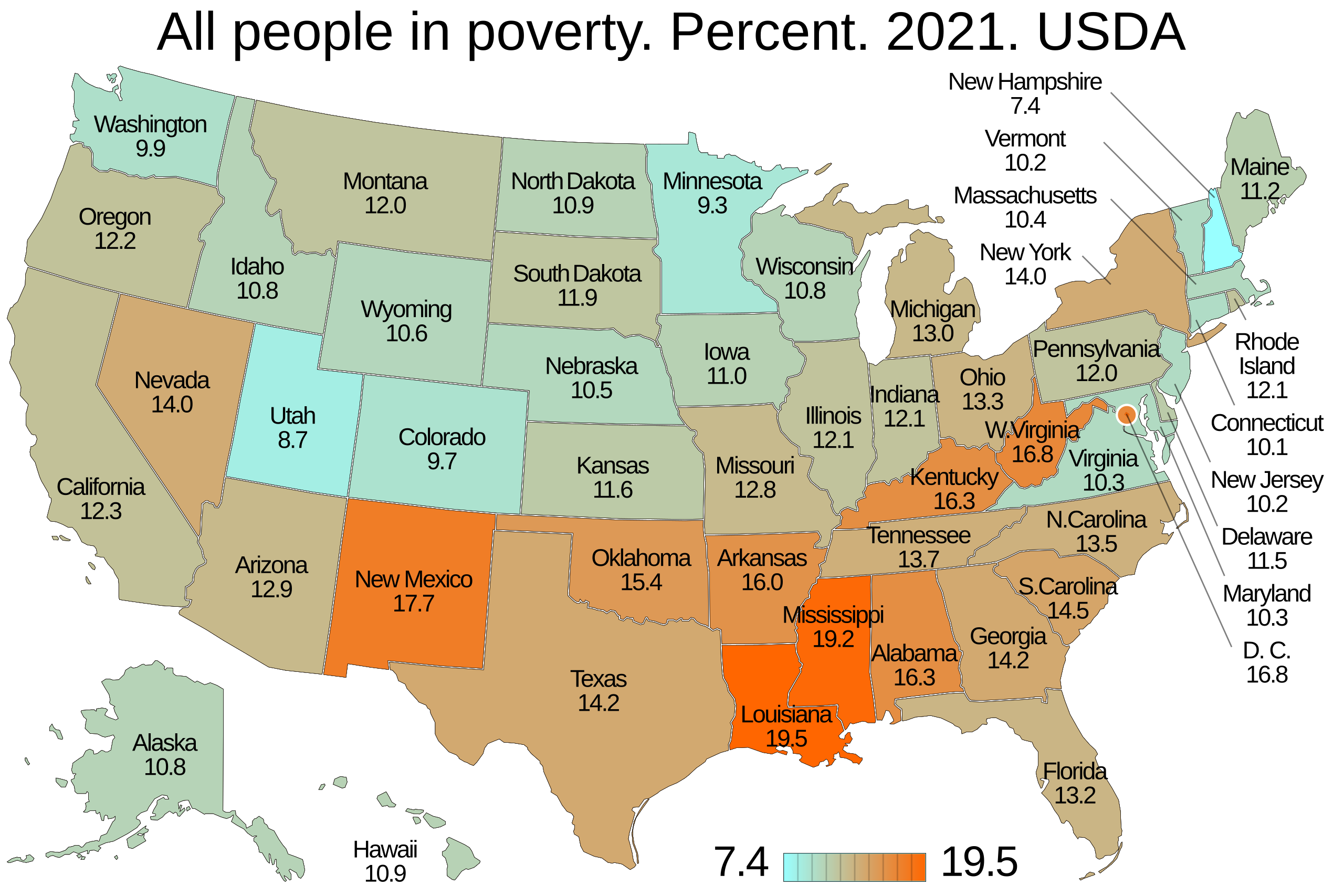
Poverty rates by state. US map
Summary[edit]
| Description |
English: Poverty rates by state. US map. United States Department of Agriculture. |
|
| Date | - date of first upload to the Commons. See file history for latest upload date. | |
| Source |
Own work from Poverty by state. From USDA. en:United States Department of Agriculture.
|
|
| Author | Timeshifter from template: File:Template map of U.S. states and District of Columbia.svg and instructions: File talk:Template map of U.S. states and District of Columbia.svg/Instructions. See more info: en:User:Timeshifter/Sandbox198 and en:User:Timeshifter/Sandbox199. |

Licensing[edit]
I, the copyright holder of this work, hereby publish it under the following license:
This file is licensed under the Creative Commons Attribution-Share Alike 4.0 International license.
- You are free:
- to share – to copy, distribute and transmit the work
- to remix – to adapt the work
- Under the following conditions:
- attribution – You must give appropriate credit, provide a link to the license, and indicate if changes were made. You may do so in any reasonable manner, but not in any way that suggests the licensor endorses you or your use.
- share alike – If you remix, transform, or build upon the material, you must distribute your contributions under the same or compatible license as the original.
File history
Click on a date/time to view the file as it appeared at that time.
| Date/Time | Thumbnail | Dimensions | User | Comment | |
|---|---|---|---|---|---|
| current | 06:59, 24 July 2023 | | 512 × 341 (46 KB) | Timeshifter (talk | contribs) | Per talk: Removed DOCTYPE line. Added: <svg version="1.1"... Changed class="name" to class="state". font-family="Liberation Sans,Arial,Helvetica,sans-serif". Text sizes: 38-30-17-17px |
| 09:04, 23 June 2023 |  | 512 × 341 (46 KB) | Timeshifter (talk | contribs) | Forgot to change from 2 decimal places to 1. It has been corrected now. | |
| 08:53, 23 June 2023 |  | 512 × 341 (46 KB) | Timeshifter (talk | contribs) | 2021 map | |
| 08:28, 17 June 2023 |  | 512 × 341 (46 KB) | Timeshifter (talk | contribs) | Fixed error. Forgot to remove "National" average. | |
| 07:02, 17 June 2023 |  | 512 × 341 (46 KB) | Timeshifter (talk | contribs) | Changed from 2 decimal places to 1. Increased legend text size. Other minor changes. | |
| 20:36, 8 June 2023 |  | 512 × 341 (46 KB) | Timeshifter (talk | contribs) | Uploaded own work with UploadWizard |
You cannot overwrite this file.
File usage on Commons
The following 2 pages use this file:
File usage on other wikis
The following other wikis use this file:
- Usage on en.wikipedia.org
- Usage on ig.wikipedia.org