File:Portugaliza map-fr.svg
Jump to navigation
Jump to search

Size of this PNG preview of this SVG file: 275 × 599 pixels. Other resolutions: 110 × 240 pixels | 220 × 480 pixels | 353 × 768 pixels | 470 × 1,024 pixels | 941 × 2,048 pixels | 1,739 × 3,785 pixels.
Original file (SVG file, nominally 1,739 × 3,785 pixels, file size: 1.55 MB)
Captions
Captions
Add a one-line explanation of what this file represents
Summary[edit]
| Description |
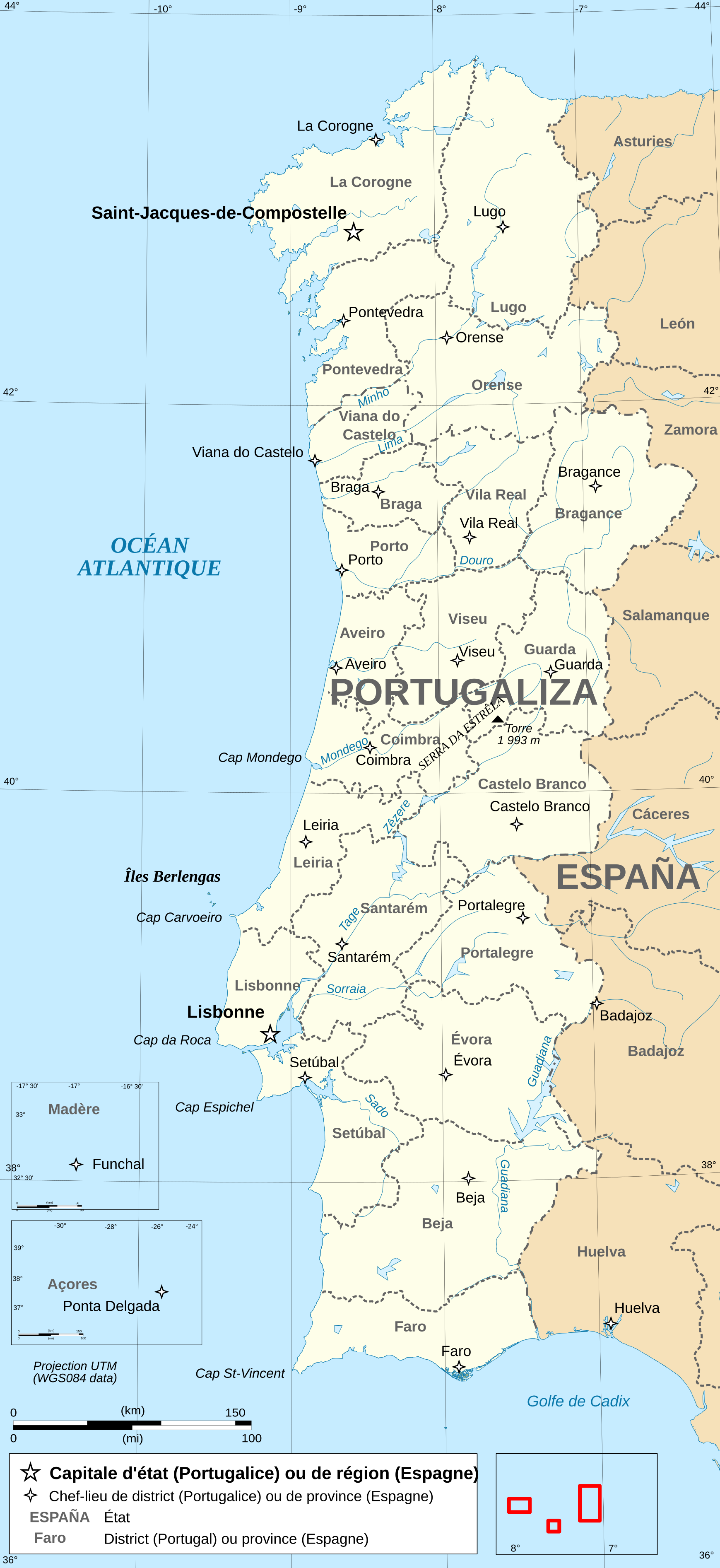
Français : Carte administrative en français de la Portugalice. Português: Carta da administração do Portugaliza Galego: Mapa de Portugaliza Deutsch: Karte von Portugalicien, französische Version English: Administrative map in French of Portugalicia Español: Mapa administrativo en francès de Portugalicia Italiano: Carta amministrativa de Portugalizia |
| Date | |
| Source | travail personnel (own work), from File:Portugal administrative map-fr.svg by uploader. Same sources for Galicia add. |
| Author | Bourrichon |
Licensing[edit]
I, the copyright holder of this work, hereby publish it under the following licenses:

|
Permission is granted to copy, distribute and/or modify this document under the terms of the GNU Free Documentation License, Version 1.2 or any later version published by the Free Software Foundation; with no Invariant Sections, no Front-Cover Texts, and no Back-Cover Texts. A copy of the license is included in the section entitled GNU Free Documentation License. |
This file is licensed under the Creative Commons Attribution-Share Alike 3.0 Unported, 2.5 Generic, 2.0 Generic and 1.0 Generic license.
- You are free:
- to share – to copy, distribute and transmit the work
- to remix – to adapt the work
- Under the following conditions:
- attribution – You must give appropriate credit, provide a link to the license, and indicate if changes were made. You may do so in any reasonable manner, but not in any way that suggests the licensor endorses you or your use.
- share alike – If you remix, transform, or build upon the material, you must distribute your contributions under the same or compatible license as the original.
You may select the license of your choice.
File history
Click on a date/time to view the file as it appeared at that time.
| Date/Time | Thumbnail | Dimensions | User | Comment | |
|---|---|---|---|---|---|
| current | 02:17, 5 February 2019 | | 1,739 × 3,785 (1.55 MB) | Tuvalkin (talk | contribs) | Corr. retângulo vermelho do mapa loc.; rmv. "ESPAGNE" sobre terr. galego; trad. top. nacionais. Rmv. tb imagens ráster. |
| 18:04, 28 April 2009 |  | 1,739 × 3,785 (6.57 MB) | Bourrichon (talk | contribs) | key | |
| 00:04, 26 April 2009 |  | 1,739 × 3,785 (6.57 MB) | Bourrichon (talk | contribs) | + "Portugal" | |
| 22:29, 25 April 2009 |  | 1,739 × 3,785 (6.57 MB) | Bourrichon (talk | contribs) | {{Information |Description={{fr|Carte administrative en français de la Portugalice.}}{{po|Carta da administração do Portugaliza}}{{gl|Portugaliza}}{{de|Karte von [[:de:Portugalicien|Portugalic |
You cannot overwrite this file.
File usage on Commons
There are no pages that use this file.
File usage on other wikis
The following other wikis use this file:
- Usage on ast.wikipedia.org
- Usage on ca.wikipedia.org
- Usage on es.wikipedia.org
- Usage on fi.wikipedia.org
- Usage on fr.wikipedia.org
- Usage on hy.wikipedia.org
- Usage on nl.wikipedia.org
- Usage on tr.wikipedia.org