File:Portioning out the bread at a road-side dump (4688608974).jpg
Jump to navigation
Jump to search

Size of this preview: 770 × 600 pixels. Other resolutions: 308 × 240 pixels | 616 × 480 pixels | 1,000 × 779 pixels.
Original file (1,000 × 779 pixels, file size: 93 KB, MIME type: image/jpeg)
Captions
Captions
Add a one-line explanation of what this file represents
Summary
[edit].jpg&action=edit§ion=1)
| Description |
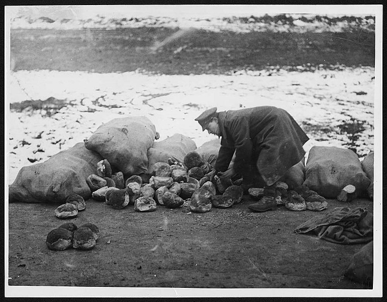
English: This image is of a soldier dividing out loaves of bread at a roadside supply dump. He has emptied the loaves out of some of the hessian sacks onto the snowy ground. The lack of hygiene in the handling of food supplies appears shocking until one reflects on the impossibility of hygiene in the trenches with the mud, sewage and dead bodies. Gastric infections were a major problem created by the poor diet and the lack of hygiene. Many First World War veterans had life-long health problems caused, in part, by the army rations. |
| Date | |
| Source | https://www.flickr.com/photos/nlscotland/4688608974/ |
| Author | National Library of Scotland |
| Permission (Reusing this file) |
At the time of upload, the image license was automatically confirmed using the Flickr API. For more information see Flickr API detail. |
| Flickr sets |
|
| Flickr tags |
|
| Camera location | | View this and other nearby images on: OpenStreetMap |
|---|
.jpg¶ms=046.710670_N_0001.718189_E_globe:Earth_type:camera__&language=en)
Licensing
[edit].jpg&action=edit§ion=2)
This image was taken from Flickr's The Commons. The uploading organization may have various reasons for determining that no known copyright restrictions exist, such as:
More information can be found at https://flickr.com/commons/usage/. Please add additional copyright tags to this image if more specific information about copyright status can be determined. See Commons:Licensing for more information. |
| This image was originally posted to Flickr by National Library of Scotland at https://flickr.com/photos/14456531@N07/4688608974. It was reviewed on 16 November 2016 by FlickreviewR and was confirmed to be licensed under the terms of the No known copyright restrictions. |
File history
Click on a date/time to view the file as it appeared at that time.
| Date/Time | Thumbnail | Dimensions | User | Comment | |
|---|---|---|---|---|---|
| current | 21:24, 12 January 2022 | | 1,000 × 779 (93 KB) | Ich (talk | contribs) | https://deriv.nls.uk/dcn30/7440/74408353.30.jpg |
| 15:18, 16 November 2016 |  | 600 × 467 (41 KB) | Fæ (talk | contribs) | National Library of Scotland, Set 72157624150609895, ID 4688608974, Original title Portioning out the bread at a road-side dump |
You cannot overwrite this file.
File usage on Commons
There are no pages that use this file.
.jpg&oldid=875568930)