File:Ponte 25 de Abril - Lisboa - Portugal (6355835665).jpg
Original file (5,148 × 3,861 pixels, file size: 4.46 MB, MIME type: image/jpeg)
Captions
Captions
Summary[edit]
.jpg&action=edit§ion=1)
| Description |
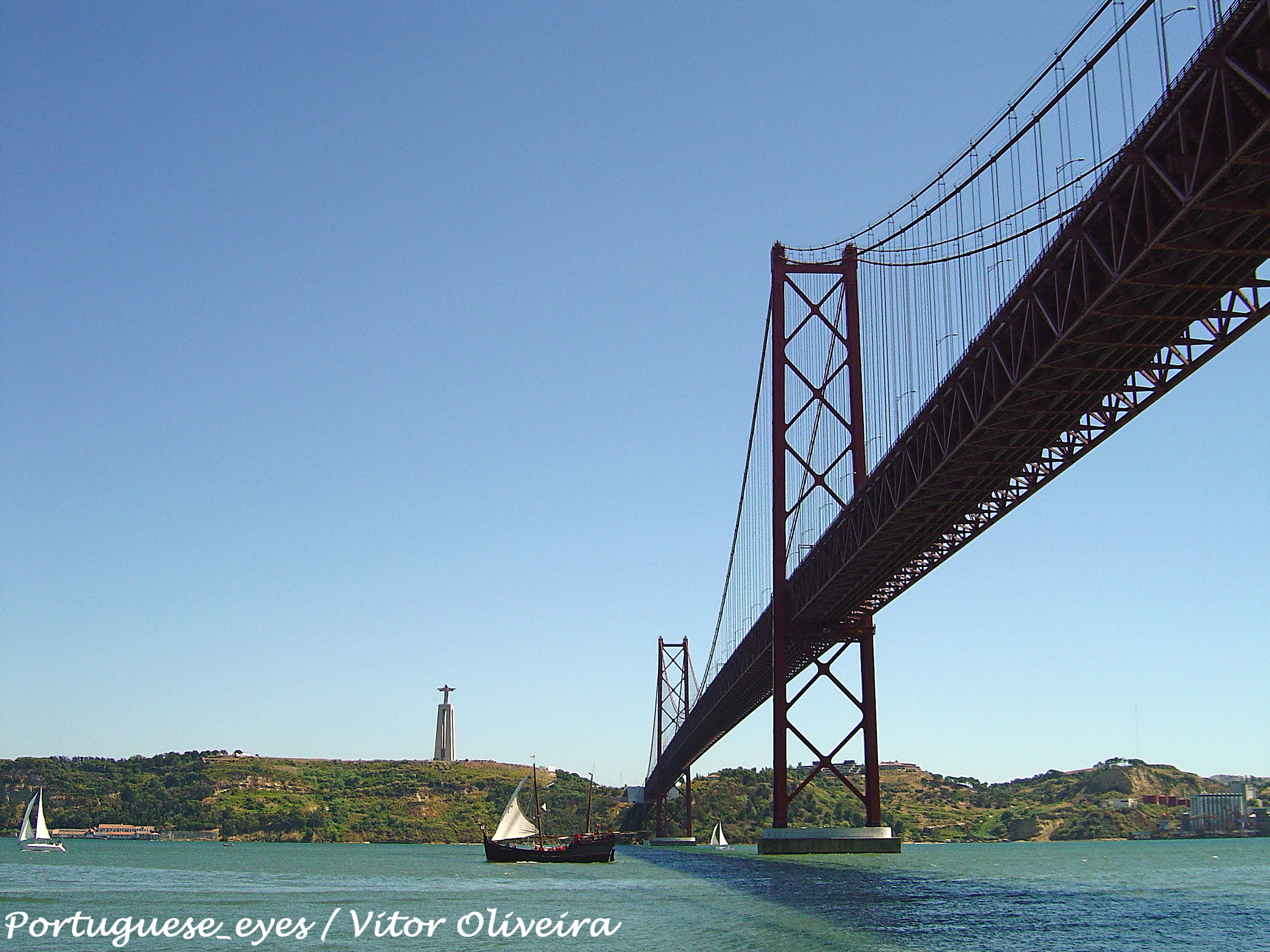
A Ponte 25 de Abril, também conhecida como Ponte sobre o Tejo, foi inaugurada em 1966 com o nome Ponte Salazar, em memória ao ditador que a mandou construir. Mais tarde, a ponte recebeu o actual nome em homenagem à 'Revolução dos Cravos' que aconteceu a 25 de Abril de 1974. Este foi um dia de revolução "não sangrenta". Na Revolução dos Cravos, os soldados puseram cravos no cano das suas armas e revoltaram-se contra a ditadura mais longa do mundo. Esta ponte é muito parecida à Ponte Golden Gate em São Francisco. Tem 2.278km de comprimentos e parte do cimo de Lisboa, mais precisamente de Alcântara e termina em Almada, na margem sul do rio. Sendo particularmente procurada aos fins-de-semana, aproveite e evite os congestionamentos e vá pela recentemente construída Ponte Vasco da Gama, ou deixe o seu carro num parque de estacionamento e apanhe o comboio que passa na parte de baixo da ponte desde 1999. Já no lado de Almada poderá ver o monumento do Cristo Rei, semelhante ao Redentor no Brasil, virado para o Tejo. Se desejar visitar o Cristo Rei, terá que subir de elevador até cerca de 82m de altitude e, uma vez lá, de certeza que ficará completamente fascinado com as vistas que pode ver sobre a cidade e sobre o rio. <a href="http://www.strawberryworld-lisbon.com/lisboa/places/ponte-abril.html" rel="nofollow">www.strawberryworld-lisbon.com/lisboa/places/ponte-abril....</a> <a href="http://loc.alize.us/#/flickr:6355835665" rel="nofollow">See where this picture was taken.</a> <a href="https://www.flickr.com/groups/geotagging/discuss/72157594165549916/">[?]</a> |
| Date | |
| Source | Ponte 25 de Abril - Lisboa - Portugal |
| Author | Vitor Oliveira from Torres Vedras, PORTUGAL |
| Camera location | | View this and other nearby images on: OpenStreetMap |
|---|
.jpg¶ms=038.698406_N_-009.178572_E_globe:Earth_type:camera_source:Flickr_&language=en)
Licensing[edit]
.jpg&action=edit§ion=2)
- You are free:
- to share – to copy, distribute and transmit the work
- to remix – to adapt the work
- Under the following conditions:
- attribution – You must give appropriate credit, provide a link to the license, and indicate if changes were made. You may do so in any reasonable manner, but not in any way that suggests the licensor endorses you or your use.
- share alike – If you remix, transform, or build upon the material, you must distribute your contributions under the same or compatible license as the original.
| This image was originally posted to Flickr by Portuguese_eyes at https://flickr.com/photos/21446942@N00/6355835665 (archive). It was reviewed on 19 March 2019 by FlickreviewR 2 and was confirmed to be licensed under the terms of the cc-by-sa-2.0. |
File history
Click on a date/time to view the file as it appeared at that time.
| Date/Time | Thumbnail | Dimensions | User | Comment | |
|---|---|---|---|---|---|
| current | 00:35, 19 March 2019 | | 5,148 × 3,861 (4.46 MB) | Tm (talk | contribs) | Transferred from Flickr via #flickr2commons |
You cannot overwrite this file.
File usage on Commons
The following page uses this file:
.jpg&oldid=663895490)