File:Pont Long (Béarn Pau).svg

Original file (SVG file, nominally 1,052 × 744 pixels, file size: 9.21 MB)
Captions
Captions
Summary[edit]
.svg&action=edit§ion=1)
| Description |
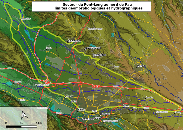
Français : Carte topographique du "Pont Long" plaine située au nord de Pau (Béarn, France)
Les limites hydrographiques retenues sont : le Luy-de-Béarn au nord, l'Ousse-des-bois au sud, l'Uzan à l'Ouest. Ces limites sont élargies aux pieds des coteaux environnants (limites géomorphologiques). Au sud, la limite est donnée par la légère ligne de pente séparant l'Uzan et l'Aygue-longue de l'Ousse. Au nord-ouest vers Mazerolles, le décrochage et l'extension de la vallée du Luy sert également de limite. Sources : Modèle numérique de terrain : EU-DEM v1.1, EEA / Copernicus calcul des pentes et couleurs d'altitude sous QGIS 3.22.4 Limites communales et centres-bourgs : AdminExpress, IGN Cours d'eau : BD Cartage, Sandre Routes : OpenStreetMap |
| Date | |
| Source | Own work |
| Author | BotaFlo |
| Camera location | | View this and other nearby images on: OpenStreetMap |
|---|
.svg¶ms=043.351300_N_-000.344900_E_globe:Earth_type:camera__&language=en)
Licensing[edit]
.svg&action=edit§ion=2)
- You are free:
- to share – to copy, distribute and transmit the work
- to remix – to adapt the work
- Under the following conditions:
- attribution – You must give appropriate credit, provide a link to the license, and indicate if changes were made. You may do so in any reasonable manner, but not in any way that suggests the licensor endorses you or your use.
- share alike – If you remix, transform, or build upon the material, you must distribute your contributions under the same or compatible license as the original.
File history
Click on a date/time to view the file as it appeared at that time.
| Date/Time | Thumbnail | Dimensions | User | Comment | |
|---|---|---|---|---|---|
| current | 22:06, 2 September 2023 | | 1,052 × 744 (9.21 MB) | BotaFlo (talk | contribs) | ajout du ruisseau de l'Ousse comme nouvelle limite au sud |
| 22:02, 2 September 2023 |  | 1,052 × 744 (9.21 MB) | BotaFlo (talk | contribs) | correction des limites au sud-est, ajout des zones artificialisées et des eaux superficielles CLC 2018 | |
| 17:03, 2 September 2023 |  | 1,052 × 744 (9.29 MB) | BotaFlo (talk | contribs) | correction de la limite nord-ouest vers Mazerolles | |
| 16:55, 2 September 2023 |  | 1,052 × 744 (9.27 MB) | BotaFlo (talk | contribs) | amélioration de la visibilité de la topographie, amélioration de de la qualité esthétique de la carte | |
| 11:14, 9 December 2019 |  | 1,052 × 744 (8.9 MB) | BotaFlo (talk | contribs) | User created page with UploadWizard |
You cannot overwrite this file.
File usage on Commons
The following page uses this file:
File usage on other wikis
The following other wikis use this file:
- Usage on fr.wikipedia.org
.svg&oldid=797932709)