File:Poland2 location map.svg

Original file (SVG file, nominally 861 × 837 pixels, file size: 341 KB)
Captions
Captions
Summary[edit]
| Description |
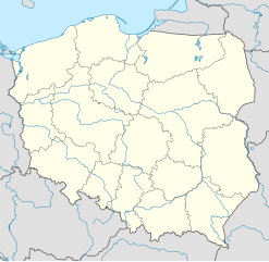
Deutsch: Positionskarte von Polen
Quadratische Plattkarte, N-S-Streckung 160 %. Geographische Begrenzung der Karte:
English: Location map of Poland
Equirectangular projection, N/S stretching 160 %. Geographic limits of the map:
|
||
| Date | |||
| Source |
Own workusing
|
||
| Author | NordNordWest | ||
| Permission (Reusing this file) |
This file is licensed under the Creative Commons Attribution-Share Alike 3.0 Germany license.
 This file is licensed under the Creative Commons Attribution-Share Alike 3.0 Unported license.
|
||
| Other versions |
|
||
| SVG development | This W3C-invalid map was created with Adobe Illustrator.
|


File history
Click on a date/time to view the file as it appeared at that time.
| Date/Time | Thumbnail | Dimensions | User | Comment | |
|---|---|---|---|---|---|
| current | 20:20, 23 November 2011 | | 861 × 837 (341 KB) | NordNordWest (talk | contribs) | == {{int:filedesc}} == {{Information |Description= {{de|Positionskarte von Polen}} Quadratische Plattkarte, N-S-Streckung 160 %. Geographische Begrenzung der Karte: * N: 55.2° N * S: 48.7° N * W: 13.8° O * O: 24.5° O {{en|Location map of |
You cannot overwrite this file.
File usage on Commons
The following 53 pages use this file:
- File:Greater Poland in Poland (+rivers).svg
- File:Greater Poland in Poland (relief).svg
- File:Greater Poland in Poland (relief + less opacity).svg
- File:Kuyavian-Pomeranian in Poland (+rivers).svg
- File:Kuyavian-Pomeranian in Poland (relief).svg
- File:Kuyavian-Pomeranian in Poland (relief + less opacity).svg
- File:Lesser Poland in Poland (+rivers).svg
- File:Lesser Poland in Poland (relief).svg
- File:Lesser Poland in Poland (relief + less opacity).svg
- File:Lodz in Poland (+rivers).svg
- File:Lodz in Poland (relief).svg
- File:Lodz in Poland (relief + less opacity).svg
- File:Lower Silesian in Poland (+rivers).svg
- File:Lower Silesian in Poland (relief).svg
- File:Lower Silesian in Poland (relief + less opacity).svg
- File:Lublin in Poland (+rivers).svg
- File:Lublin in Poland (relief).svg
- File:Lublin in Poland (relief + less opacity).svg
- File:Lubusz in Poland (+rivers).svg
- File:Lubusz in Poland (relief).svg
- File:Lubusz in Poland (relief + less opacity).svg
- File:Masovian in Poland (+rivers).svg
- File:Masovian in Poland (relief).svg
- File:Masovian in Poland (relief + less opacity).svg
- File:Opolskie in Poland (+rivers).svg
- File:Opolskie in Poland (relief).svg
- File:Opolskie in Poland (relief + less opacity).svg
- File:Podkarpackie in Poland (+rivers).svg
- File:Podkarpackie in Poland (relief).svg
- File:Podkarpackie in Poland (relief + less opacity).svg
- File:Podlaskie in Poland (+rivers).svg
- File:Podlaskie in Poland (relief).svg
- File:Podlaskie in Poland (relief + less opacity).svg
- File:Poland2 location map.svg
- File:Poland location map.svg
- File:Poland location map 3.svg
- File:Pomeranian in Poland (+rivers).svg
- File:Pomeranian in Poland (relief).svg
- File:Pomeranian in Poland (relief + less opacity).svg
- File:Relief Map of Poland.png
- File:Relief Map of Poland.svg
- File:Silesian in Poland (+rivers).svg
- File:Silesian in Poland (relief).svg
- File:Silesian in Poland (relief + less opacity).svg
- File:Swietokrzyskie in Poland (+rivers).svg
- File:Swietokrzyskie in Poland (relief).svg
- File:Swietokrzyskie in Poland (relief + less opacity).svg
- File:Warmian-Masurian in Poland (+rivers).svg
- File:Warmian-Masurian in Poland (relief).svg
- File:Warmian-Masurian in Poland (relief + less opacity).svg
- File:West Pomeranian in Poland (+rivers).svg
- File:West Pomeranian in Poland (relief).svg
- File:West Pomeranian in Poland (relief + less opacity).svg
.svg)
.svg)
.svg)
.svg)
.svg)
.svg)
.svg)
.svg)
.svg)
.svg)
.svg)
.svg)
.svg)
.svg)
.svg)
.svg)
.svg)
.svg)
.svg)
.svg)
.svg)
.svg)
.svg)
.svg)
.svg)
.svg)
.svg)
.svg)
.svg)
.svg)
.svg)
.svg)
.svg)
.svg)
.svg)
.svg)
.svg)
.svg)
.svg)
.svg)
.svg)
.svg)
.svg)
.svg)
.svg)
.svg)
.svg)
.svg)
File usage on other wikis
The following other wikis use this file:
- Usage on av.wikipedia.org
- Usage on de.wikipedia.org
- Usage on es.wikipedia.org
- Usage on id.wikipedia.org
- Usage on kk.wikipedia.org
- Usage on nds-nl.wikipedia.org
- Usage on pfl.wikipedia.org
- Usage on pl.wiktionary.org
- Usage on zh.wikipedia.org