File:Plan of the Odra border river near Bohumín.jpg
Jump to navigation
Jump to search

Size of this preview: 800 × 471 pixels. Other resolutions: 320 × 188 pixels | 640 × 377 pixels | 1,024 × 603 pixels | 1,280 × 753 pixels | 2,560 × 1,506 pixels | 4,738 × 2,788 pixels.
Original file (4,738 × 2,788 pixels, file size: 5.14 MB, MIME type: image/jpeg)
Captions
Captions
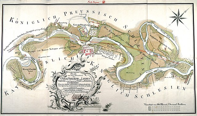
Plan of the Odra border river near Bohumín from 1769
Summary[edit]
| Description |
English: Geometrical plan of the situation of the course of the Oder and the state boundary in the area of the town and castle of Oderberg (now Old Bohumín, Czechia) after the extraordinary floods that occurred there, of the water cracks that resulted, and of the demolition of the steep terrain, as well as of the communal commission that was formed as a result, and of the defensive works or canals proposed to remedy them, surveyed in the months of June and October and put into this form in December 1769.
The border itself is marked with the red line.
Čeština: Geometrický plán situace toku Odry a státní hranice v oblasti města a zámku Oderberg (dnes Starý Bohumín) po mimořádných záplavách, které se tam vyskytly, o vodních trhlinách, které tím vznikly, a o bourání strmých terénů, jakož i o komunální komisi, která se proto vznikla, a o obranných pracích nebo kanálech navržených k jejich nápravě, vyměřených v měsících červnu a říjnu a uvedených do této podoby v prosinci 1769.
Fond: Královský úřad Opava; technika záznamu: perokresba, nosič záznamu: papír, barevnost: kolorováno; měřítko: rýnské desetinné pruty; rozměry: 84,5 x 50,5 cm. Hranice je vyznačena červenou čarou.Deutsch: Geometrischer Plan von der Situation des OderStrohms und LandesGrentze in der Gegend der Stadt und Schlosses Oderberg über die daselbst entstandene außerordentliche Überschwemmung, dadurch verursachte Wasser - Einrisse, und Abbrüche derer Steüerbahren Gründe, als deshalb vorgewesene Gemeinschafftliche Commißion und zu deren Abhelffung in Vorschlag gebrachte Defensions Werke oder Canäle vermessen im Monath Iuni und October, und in dieser Proportion gebracht im December 1769. |
| Date | |
| Source | Digitální archiv Zemského archivu v Opavě |
| Author | Arnold Neüwertz, Tolentin Schonat |
Licensing[edit]
|
This work is in the public domain in its country of origin and other countries and areas where the copyright term is the author's life plus 70 years or fewer. This work is in the public domain in the United States because it was published (or registered with the U.S. Copyright Office) before January 1, 1929. | |
| This file has been identified as being free of known restrictions under copyright law, including all related and neighboring rights. | |
| Annotations | This image is annotated: View the annotations at Commons |
File history
Click on a date/time to view the file as it appeared at that time.
| Date/Time | Thumbnail | Dimensions | User | Comment | |
|---|---|---|---|---|---|
| current | 07:20, 19 October 2022 | | 4,738 × 2,788 (5.14 MB) | Plánovací kalendář (talk | contribs) | Uploaded a work by Arnold Neüwertz, Tolentin Schonat from [https://digi.archives.cz/da/VysledekBean.action?show=&_sourcePage=asOt2VieMV2Eus1dKxV02b1UiAXm2hPubiQCbzdsQQ1ac2Bps5HT4D5J6LYjlfqOWf-GnuWhacffQsIVZwcbToQ7A7mjG5jY7B4mnrIKZVY%3D&pagerCompStateId=PAGER_RESULT&xid=BE4BB9CD4E0C11E489CA001167D6B623&entityType=10042&paginatorCompStateId=PAGINATOR_RESULT&rowPg=4 Digitální archiv zemského archivu v Opavě] with UploadWizard |
You cannot overwrite this file.
File usage on Commons
The following 2 pages use this file:
File usage on other wikis
The following other wikis use this file:
- Usage on cs.wikipedia.org
- Usage on pl.wikipedia.org