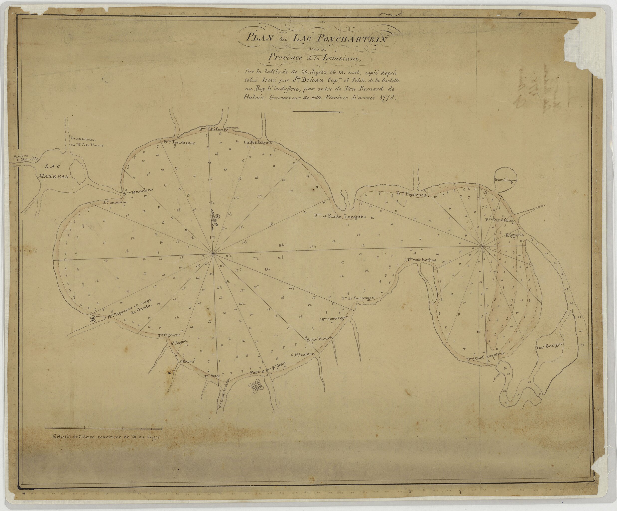
File:Plan du Lac Ponchartrin dans la Province de la Louisiane, Par la latitude de 30, degréz, 36. m. nort. Copié d'aprés celui Levé par Jph. Briones Capne. Et Pilote de la Goelette au Ro - DPLA - 0c6fba6b7453d6a5c89e990d51862b21.jpg
From Wikimedia Commons, the free media repository
Jump to navigation
Jump to search
Size of this preview: 724 × 600 pixels. Other resolutions: 290 × 240 pixels | 580 × 480 pixels | 927 × 768 pixels | 1,236 × 1,024 pixels | 2,473 × 2,048 pixels | 6,632 × 5,493 pixels.
Original file (6,632 × 5,493 pixels, file size: 2.66 MB, MIME type: image/jpeg)
File information
Structured data
Captions
Summary[edit]
Creator InfoField | War Department. Office of the Chief of Engineers. 1818-9/18/1947 | |||||||||||||
Title |
Plan du Lac Ponchartrin dans la Province de la Louisiane, Par la latitude de 30, degréz, 36. m. nort. Copié d'aprés celui Levé par Jph. Briones Capne. Et Pilote de la Goelette au Roy L'indufrie, par ordre de Don Bernad de Galvé Gouverneur de cette Province L'année 1778 |
|||||||||||||
Date |
1778 date QS:P571,+1778-00-00T00:00:00Z/9 |
|||||||||||||
Collection |
institution QS:P195,Q59661038 |
|||||||||||||
Source/Photographer |
|
|||||||||||||
Permission (Reusing this file) |
|
|||||||||||||
Standardized rights statement InfoField |
|
File history
Click on a date/time to view the file as it appeared at that time.
Date/Time | Thumbnail | Dimensions | User | Comment | |
---|---|---|---|---|---|
current | 11:13, 24 November 2020 | 6,632 × 5,493 (2.66 MB) | DPLA bot (talk | contribs) | Uploading DPLA ID 0c6fba6b7453d6a5c89e990d51862b21 |
You cannot overwrite this file.
File usage on Commons
The following page uses this file:
Metadata
This file contains additional information such as Exif metadata which may have been added by the digital camera, scanner, or software program used to create or digitize it. If the file has been modified from its original state, some details such as the timestamp may not fully reflect those of the original file. The timestamp is only as accurate as the clock in the camera, and it may be completely wrong.
Image title |
|
---|---|
Camera manufacturer | Cruse Spezialmaschinen GmbH |
Copyright holder |
|
Width | 7,648 px |
Height | 8,192 px |
Bits per component |
|
Compression scheme | Uncompressed |
Pixel composition | RGB |
Orientation | Normal |
Number of components | 3 |
Horizontal resolution | 300 dpi |
Vertical resolution | 300 dpi |
Data arrangement | chunky format |
Software used | Adobe Photoshop CS6 (Windows) |
File change date and time | 12:44, 20 July 2017 |
Exif version | 2.21 |
Color space | Uncalibrated |
Date and time of digitizing | 07:33, 12 July 2017 |
Date metadata was last modified | 08:44, 20 July 2017 |
Unique ID of original document | xmp.did:0EAC49051567E711857B8111BE74CB07 |
Structured data
Items portrayed in this file
depicts
some value
Plan du Lac Ponchartrin dans la Province de la Louisiane, Par la latitude de 30, degréz, 36. m. nort. Copié d'aprés celui Levé par Jph. Briones Capne. Et Pilote de la Goelette au Roy L'indufrie, par ordre de Don Bernad de Galvé Gouverneur de cette Province L'année 1778 (English)
image/jpeg
Hidden categories:
- Media contributed by the Digital Public Library of America
- Media contributed by the National Archives and Records Administration
- Media contributed by National Archives at College Park - Cartographic
- PD US
- Artworks without Wikidata item
- Media contributed by National Archives at College Park - Cartographic (manual series check needed)
- Files with no machine-readable author