File:Plan de l'île d'Orléans de Joseph-Camille Pouliot reproduisant la carte faite en 1689 par Villeneuve.jpg
Jump to navigation
Jump to search

Size of this preview: 800 × 369 pixels. Other resolutions: 320 × 148 pixels | 640 × 295 pixels | 1,024 × 473 pixels | 1,280 × 591 pixels | 2,560 × 1,182 pixels | 5,466 × 2,523 pixels.
Original file (5,466 × 2,523 pixels, file size: 1.69 MB, MIME type: image/jpeg)
Captions
Captions
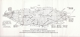
Map of the Ile d'Orleans in 1689, including the location of parishes and lands granted to early settlers of this region of New France.
Summary
[edit]
| Description |
Français : Plan de l'île d'Orléans reproduisant la carte faite en 1689 par Villeneuve, ingénieur du Roi, et la complétant par des indications tirées du cadastre, des titres seigneuriaux, etc. |
| Date | |
| Source | POULIOT, Joseph-Camille. L'Île d'Orléans, glanures historiques et familiales, Québec, 1927, p. 174. |
| Author | Joseph-Camille Pouliot |
Licensing
[edit]
The author died in 1935, so this work is in the public domain in its country of origin and other countries and areas where the copyright term is the author's life plus 80 years or fewer. | |
| This file has been identified as being free of known restrictions under copyright law, including all related and neighboring rights. | |
| Annotations | This image is annotated: View the annotations at Commons |
File history
Click on a date/time to view the file as it appeared at that time.
| Date/Time | Thumbnail | Dimensions | User | Comment | |
|---|---|---|---|---|---|
| current | 03:27, 13 August 2015 | | 5,466 × 2,523 (1.69 MB) | ThoMiCroN (talk | contribs) | Plan sans texte rouge. (Merci à Marcel W. Landry.) |
| 07:33, 16 July 2014 |  | 5,466 × 2,523 (1.89 MB) | ThoMiCroN (talk | contribs) | User created page with UploadWizard |
You cannot overwrite this file.
File usage on Commons
There are no pages that use this file.
File usage on other wikis
The following other wikis use this file: