File:Pl. P. Vauboin, Tassin - 69.jpg
Jump to navigation
Jump to search

Size of this preview: 450 × 600 pixels. Other resolutions: 180 × 240 pixels | 360 × 480 pixels | 852 × 1,136 pixels.
Original file (852 × 1,136 pixels, file size: 185 KB, MIME type: image/jpeg)
Captions
Captions
Add a one-line explanation of what this file represents
Summary[edit]
| Description |
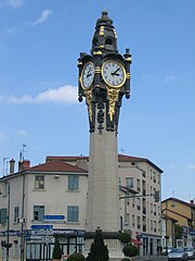
Français : Point de repère incontournable de l'ouest lyonnais, la pl. Pierre Vauboin de Tassin la Demi-Lune, aussi connue des locaux comme place de l'horloge.
Elle permet de rallier A6, périphérique nord et Vaise, Perrache via Saint-Just et la montée de Choulans, par dessus le tunnel de Fourvière, à l'est. |
| Date | |
| Source | Own work |
| Author | Nanzig |
| Camera location | | View this and other nearby images on: OpenStreetMap |
|---|
Licensing[edit]
I, the copyright holder of this work, hereby publish it under the following license:
This file is licensed under the Creative Commons Attribution-Share Alike 4.0 International license.
- You are free:
- to share – to copy, distribute and transmit the work
- to remix – to adapt the work
- Under the following conditions:
- attribution – You must give appropriate credit, provide a link to the license, and indicate if changes were made. You may do so in any reasonable manner, but not in any way that suggests the licensor endorses you or your use.
- share alike – If you remix, transform, or build upon the material, you must distribute your contributions under the same or compatible license as the original.
File history
Click on a date/time to view the file as it appeared at that time.
| Date/Time | Thumbnail | Dimensions | User | Comment | |
|---|---|---|---|---|---|
| current | 11:52, 13 July 2018 | | 852 × 1,136 (185 KB) | Nanzig (talk | contribs) | User created page with UploadWizard |
You cannot overwrite this file.
File usage on Commons
There are no pages that use this file.