File:Pictorial Map of the Tōkaidō Highroad WDL9933.jpg
Jump to navigation
Jump to search

Size of this preview: 800 × 146 pixels. Other resolutions: 320 × 58 pixels | 640 × 117 pixels | 1,024 × 187 pixels | 1,280 × 234 pixels | 5,611 × 1,024 pixels.
Original file (5,611 × 1,024 pixels, file size: 885 KB, MIME type: image/jpeg)
Captions
Captions
Add a one-line explanation of what this file represents
Summary[edit]
| Author |
|
|||||||||||||||||||||||
| Title |
Русский: Графическая карта пути Токайдо
Français : Carte picturale de la grand-route du Tōkaidō
English: Pictorial Map of the Tōkaidō Highroad
中文:东海道文间绘图
Português: Mapa figurativo da estrada Tōkaidō
العربية: خريطة تصويرية لطريق توكايدو الرئيسي
Español: Mapa pictórico de la carretera de Tōkaidō |
|||||||||||||||||||||||
| Description |
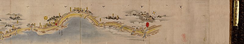
Русский: Эта графическая карта изображает путь Токайдо, пролегавший между городами Эдо (Токио) и Киото. Первоначальная "Tōkaidō Bunken Ezu" (масштабная карта Токайдо) была создана мастером ксилографии Хисикава Моронобу (около 1618—1694 гг.) в 1690 г. на основе съемки дороги, проведенной в 1651 г. Были распространены различные виды этой карты, в том числе черно-белые гравюры и большие свитки, которые нужно было разворачивать на столe для воображаемого "путешествия в кресле". Этот экземпляр был выполнен чернилами и акварелью в виде двух небольших свитков, благодаря чему можно предположить, что эта карта предназначалась как практическое руководство для путешественников. Расстояния приведены в точном масштабе, однако направления различаются в зависимости от области и отмечены квадратами с указанием сторон света. В описание входят основные города, "станции", где уставшие путешественники могли отдохнуть или взять на прокат коня, и советы, где можно найти лодку. На карте также отмечены достопримечательности, в том числе храмы и места поклонения, живописные пейзажи и места, связанные с историческими событиями и местными преданиями. Карты, подобные этой, служили практическим инструментом для путешественников, а также отражали общепринятые взгляды на географию, историю и мифологию.
Рукописные карты; Иллюстрированные карты; Дороги Français : Cette carte picturale représente la grand-route du Tōkaidō, qui reliait les villes d'Edo (Tokyo) et de Kyoto. L'original de la Tōkaidō Bunken Ezu (Carte à l'échelle du Tōkaidō) fut dessiné en 1690 par Hishikawa Moronobu (1618–1694 environ), artiste utilisant la technique de l'impression au bloc de bois, et repose sur une étude topographique de la route effectuée en 1651. Diverses itérations de cette carte circulèrent, notamment des impressions en noir et blanc, et des grands rouleaux destinés à être déroulés sur un bureau lors des voyages en fauteuil. Cette version est peinte à l'encre et à l'aquarelle sur deux rouleaux plus petits, suggérant qu'elle était destinée à servir de guide pratique aux voyageurs. Les distances sont à l'échelle exacte, mais les directions varient en fonction de la région et sont indiquées par des carrés représentant des boussoles. Les villes majeures sont incluses dans la carte, ainsi que les « haltes » où les voyageurs épuisés pouvaient se reposer ou louer un cheval, et obtenir des informations sur la mise à disposition de bateaux. La carte signale les points d'intérêt, tels que les temples et les sanctuaires ou les paysages pittoresques. Elle révèle aussi des repères associés à des événements historiques et à des mythes locaux. Les cartes, telles que celle présentée ici, étaient à la fois des instruments pratiques pour les voyageurs et un reflet des opinions courantes sur la géographie, l'histoire et le savoir mythique.
Cartes manuscrites; Cartes picturales; Routes English: This pictorial map depicts the Tōkaidō Highroad which ran between the cities of Edo (Tokyo) and Kyoto. The original Tōkaidō Bunken Ezu (Scale map of the Tōkaidō) was drawn by woodblock artist Hishikawa Moronobu (circa 1618–94) in 1690, based on a survey of the road made in 1651. Various iterations of this map have circulated, including black and white prints and large scrolls meant to be spread out on a desk for armchair traveling. This version is painted with ink and watercolor on two smaller scrolls, suggesting it was intended as a practical guide for travelers. Distances are represented on an accurate scale, but directions vary depending on the area and are marked by compass squares. Included in the description are major cities, “stations” where worn-out travelers could rest or rent a horse, and advice on where boats were available. The map also notes places of interest, such as temples and shrines, scenic landscapes, and landmarks associated with historic events and local myths. Maps such as this were both practical tools for travelers and a reflection of commonly held views of geography, history, and mythical knowledge.
Manuscript maps; Pictorial maps; Roads 中文:这幅图示地图描绘了连接江户(东京)与京都的东海道道路。 原来的 Tōkaidō Bunken Ezu(东海道比例图)由木版艺术家菱川师宣(Hishikawa Moronobu,约 1618-1694 年)根据 1651 年的一次道路勘测绘制于 1690 年。这幅地图有多个版本的复制品在市面出现,包括黑白印制版本和大卷轴版本(即要在桌子上摊开看用于神游的版本)。 这个版本使用墨水和水彩绘制在两个较小的卷轴上,表明它是供游客使用的实用指南。 距离以准确的比例标示,但方向根据区域的不同而有所不同,并以指南针方块标记。 说明中介绍了主要城市、供劳累的游客休息或租马的“站点”以及关于哪里有船的指示。 地图还标出了旅游景点,如寺庙和神社、优美的景观以及与历史事件和当地神话相关的地标。 此类地图既是游客的实用工具,也反映了大众普遍持有的地理、历史和神话知识。
手绘地图; 图示地图; 公路 Português: Este mapa figurativo retrata a estrada Tōkaidō, que ligava as cidades de Edo (Tóquio) e Kyoto. O Tōkaidō Bunken Ezu (Mapa em escala de Tōkaidō) original foi desenhado pelo xilógrafo Hishikawa Moronobu (1618–1694) em 1690, com base na topografia da estrada feita em 1651. Várias cópias deste mapa circularam, incluindo impressões em preto e branco e rolos grandes destinados a serem abertos em uma mesa durante a viagem. Esta versão é pintada com tinta e aquarela em dois rolos menores, sugerindo que ele fosse destinado a servir de guia prático para viajantes. As distâncias são representadas em uma escala precisa, mas as direções variam conforme a área e estão marcadas por rosas dos ventos. Incluem-se na descrição as principais cidades, “estações” onde os viajantes cansados podiam descansar ou alugar um cavalo, e informações sobre onde encontrar barcos. O mapa também traz locais de interesse, como tempos e santuários, paisagens cênicas e marcos arquitetônicos associados a eventos históricos e mitos locais. Mapas como este constituíam, a um só tempo, ferramentas práticas para viajantes e um reflexo de ideias comuns de conhecimento geográfico, histórico e mítico.
Mapas manuscritos; Mapas pictóricos; Estradas العربية: توضح هذه الخريطة التصويرية طريق توكايدو الرئيسي والذي يمر بين مدن إيدو (طوكيو) وكيوتو. قام رسام المطبوعات الخشبية هيشيكاوا مورونوبو (حوالي 1618-1694) برسم توكايدو بونكن إزو (خريطة مقياس لتوكايدو) الأصلية عام 1690، وذلك اعتماداً على مسح للشارع أُجرِيَ في 1615. وتم تداول نسخ كثيرة لهذه الخريطة، بما في ذلك مطبوعات باللونين الأسود والأبيض ولفائف كبيرة والتي كانت مُعَدّة لتوضع على منضدة للتمتع بمشاهدها أثناء الجلوس. هذه النسخة مرسومة بالحبر والرَّسم المائي على لفافتين أصغر حجماً، مما يدل على أنها كانت مُصممة كدليل عملي للمسافرين. تُوضح المسافات على مقياس دقيق، ولكن الاتجاهات تختلف تبعاً للمنطقة وهي موضحة بمربعات بوصلية. كما تظهر بالخريطة المدن الرئيسية، و"محطات" حيث يمكن للمسافرين المنهكين الاستراحة أو استئجار خيول، ومعلومات عن أماكن العثور على مركب. كما تحوي الخريطة المعالم الرئيسية، مثل المعابد والأضرحة والمناظر الطبيعية الخلابة والمعالم البارزة المرتبطة بالأحداث التاريخية والأساطير المحلية. كانت مثل هذه الخرائط تُعد أدوات عملية للمسافرين وانعكاساً للآراء الشائعة حول الجغرافية والتاريخ والمعتقدات الأسطورية.
الخرائط المخطوطة; خرائط مصورة; الطرق Español: Este mapa pictórico muestra la carretera de Tōkaidō, que iba entre las ciudades de Edo (Tokio) y Kioto. El mapa original, Tōkaidō Bunken Ezu (Mapa en escala de Tōkaidō) fue dibujado por el artista xilográfico Hishikawa Moronobu (circa 1618-1694) en 1690, sobre la base de un estudio de la carretera hecho en 1651. Estuvieron en circulación diferentes variantes de este mapa, incluidas impresiones en blanco y negro y rollos grandes que podían desplegarse sobre un escritorio para poder viajar sin tener que transportarse. Esta versión está pintada con tinta y acuarela sobre dos rollos más pequeños, lo que sugiere que fue concebida como una guía práctica para los viajeros. Las distancias están representadas en una escala exacta, pero las direcciones varían según la zona y están marcadas por medio de brújulas en forma de rombo. En la descripción se mencionan las ciudades importantes, las «estaciones» donde los viajeros cansados podían descansar o alquilar un caballo, y consejos sobre dónde había barcos disponibles. El mapa también indica los lugares de interés, como templos y santuarios, paisajes pintorescos y lugares destacados relacionados con acontecimientos históricos y mitos locales. Los mapas como este eran herramientas prácticas para los viajeros y también un reflejo de las opiniones más arraigadas acerca de la geografía, la historia y el conocimiento mítico.
Mapas manuscritos; Mapas pictóricos; Caminos |
|||||||||||||||||||||||
| Date | between 1600 and 1699 | |||||||||||||||||||||||
| Medium |
Русский: Карты
Français : Cartes
English: Maps
中文:地图
Português: Mapas
العربية: خرائط
Español: Mapas |
|||||||||||||||||||||||
| Dimensions |
English: 1 map on 2 sheets : manuscript, pen and ink watercolor, mounted on 2 scrolls ; 3,575 x 26 centimeters, sheets 1,722 x 26 centimeters and 1,853 x 26 centimeters. |
|||||||||||||||||||||||
| Collection |
Русский: Библиотека Конгресса
Français : Bibliothèque du Congrès
English: Library of Congress
中文:国会图书馆
Português: Biblioteca do Congresso
العربية: مكتبة الكونغرس
Español: Biblioteca del Congreso |
|||||||||||||||||||||||
| Place of creation |
Русский: Киото
Français : Kyoto
English: Kyoto
中文:京都府
Português: Quioto
العربية: كيوتو
Español: Kioto |
|||||||||||||||||||||||
| Notes |
Original language title: 東海道文間絵図 Русский: Масштаб не выдержан.
Français : La carte n'est pas dessinée à l'échelle.
English: Not drawn to scale.
中文:无比例尺。
Português: Não está desenhado em escala.
العربية: ليست مرسومة حسب المقياس.
Español: No está dibujado a escala. |
|||||||||||||||||||||||
| References | http://hdl.loc.gov/loc.wdl/dlc.9933 | |||||||||||||||||||||||
| Source/Photographer |
http://www.wdl.org/media/9933/service/thumbnail/6000x6000/1/1.jpg
|
|||||||||||||||||||||||

Licensing[edit]
|
This is a faithful photographic reproduction of a two-dimensional, public domain work of art. The work of art itself is in the public domain for the following reason:
The official position taken by the Wikimedia Foundation is that "faithful reproductions of two-dimensional public domain works of art are public domain".
This photographic reproduction is therefore also considered to be in the public domain in the United States. In other jurisdictions, re-use of this content may be restricted; see Reuse of PD-Art photographs for details. | ||||
File history
Click on a date/time to view the file as it appeared at that time.
| Date/Time | Thumbnail | Dimensions | User | Comment | |
|---|---|---|---|---|---|
| current | 05:30, 12 March 2014 | 5,611 × 1,024 (885 KB) | Fæ (talk | contribs) | =={{int:filedesc}}== {{Artwork |artist = |author ={{ru|1=Моронобу, Хисикава, около 1618 -1694}} {{fr|1=Moronobu, Hishikawa (1618-1694 env.)}} {{en|1=Hishikawa, Moronobu, circa 1618-circa 1694}} {{zh|1=菱川师宣, 约1618-约1694}... |
You cannot overwrite this file.
File usage on Commons
The following page uses this file:
File usage on other wikis
The following other wikis use this file:
- Usage on ja.wikipedia.org