File:Phjongna vonal térkép.png
Jump to navigation
Jump to search

Size of this preview: 539 × 600 pixels. Other resolutions: 216 × 240 pixels | 431 × 480 pixels | 977 × 1,087 pixels.
Original file (977 × 1,087 pixels, file size: 29 KB, MIME type: image/png)
Captions
Captions
Add a one-line explanation of what this file represents
Summary[edit]
| Description |
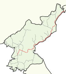
Magyar: Észak-Korea egyik legfontosabb vasútvonalának térképe.
한국어: 조선민주주의인민공화국의 중요한 선인 평라선의 지도입니다.
English: Map of Pyongra line, one of the most important lines of North Korea. |
||
| Date | |||
| Source |
This file was derived from: North korea railways.png |
||
| Author | Voland77 at German Wikipedia, Oppashi at Hungarian Wikipedia | ||
| Permission (Reusing this file) |
|
File history
Click on a date/time to view the file as it appeared at that time.
| Date/Time | Thumbnail | Dimensions | User | Comment | |
|---|---|---|---|---|---|
| current | 08:28, 27 February 2016 | | 977 × 1,087 (29 KB) | Xing (talk | contribs) | {{Information |Description ={{hu|1=Észak-Korea egyik legfontosabb vasútvonalának térképe.}} {{ko|1=조선민주주의인민공화국의 중요한 선인 평라선의 지도입니다.}} {{en|1=Map of Pyongra line, one of the most important lines... |
You cannot overwrite this file.
File usage on Commons
There are no pages that use this file.
File usage on other wikis
The following other wikis use this file:
- Usage on ja.wikipedia.org
- Usage on pl.wikipedia.org