File:Peene.png
Jump to navigation
Jump to search

Size of this preview: 763 × 600 pixels. Other resolutions: 306 × 240 pixels | 611 × 480 pixels | 938 × 737 pixels.
Original file (938 × 737 pixels, file size: 135 KB, MIME type: image/png)
Captions
Captions
Add a one-line explanation of what this file represents
Summary[edit]
| Description |
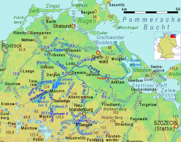
English: Peene River and its affluents in a cut of a relief map of Mecklenburg-Western Pomerania:
Brown figures = soil above sea level in meters (measure at the point, name above or below) dark blue figures = water level above sea level in meters dark blue arrows = direction of water flow, emphasized rivers drawn in stronger colours, lilac = water bodies crossing divides Deutsch: Peene und ihre Nebenflüsse sowie der Peenestrom im Ausschnitt einer physischen Karte von Mecklenburg-Vorpommern: braune Zahlen = Höhen über NHN (Zahl auf Höhenpunkt, Name darüber oder darunter) dunkelblaue Zahlen = Wasserspiegel über HN dunkelblaue Pfeile = Strömungsrichtung, thematisierte Flüsse in kräftigeren Farben, lila = Gewässer kreuzt Wasserscheide. |
| Source |
Adapted cut of Image:Mecklenburg-Vorpommern.gif , created by myself in 2008 using http://www.maps-for-free.html |
| Author | Ulamm (talk) 18:57, 20 November 2013 (UTC) |
| Permission (Reusing this file) |
File:Peene & Trebel.png, emphasizing the affluent Trebel |
Licensing[edit]
This file is licensed under the Creative Commons Attribution-Share Alike 3.0 Unported license.
- You are free:
- to share – to copy, distribute and transmit the work
- to remix – to adapt the work
- Under the following conditions:
- attribution – You must give appropriate credit, provide a link to the license, and indicate if changes were made. You may do so in any reasonable manner, but not in any way that suggests the licensor endorses you or your use.
- share alike – If you remix, transform, or build upon the material, you must distribute your contributions under the same or compatible license as the original.
File history
Click on a date/time to view the file as it appeared at that time.
| Date/Time | Thumbnail | Dimensions | User | Comment | |
|---|---|---|---|---|---|
| current | 22:48, 25 December 2018 | | 938 × 737 (135 KB) | Ulamm (talk | contribs) | colours a bit revised |
| 22:30, 25 December 2018 |  | 938 × 737 (135 KB) | Ulamm (talk | contribs) | ranking of the wells and some other details | |
| 14:38, 19 May 2016 |  | 938 × 737 (136 KB) | Ulamm (talk | contribs) | 0,1->0,5 | |
| 09:29, 19 May 2016 |  | 938 × 737 (136 KB) | Ulamm (talk | contribs) | this should have been another cut | |
| 09:27, 19 May 2016 |  | 689 × 737 (106 KB) | Ulamm (talk | contribs) | elevations around Tribsees | |
| 17:13, 15 May 2016 |  | 938 × 737 (136 KB) | Ulamm (talk | contribs) | one elevation | |
| 22:46, 14 May 2016 |  | 938 × 737 (136 KB) | Ulamm (talk | contribs) | upper courses of Tollense and Trebel | |
| 01:33, 14 May 2016 |  | 938 × 737 (135 KB) | Ulamm (talk | contribs) | Stavenhagen & Augraben | |
| 22:29, 13 May 2016 |  | 938 × 737 (135 KB) | Ulamm (talk | contribs) | major bridges and some more places | |
| 14:28, 13 May 2016 |  | 938 × 737 (134 KB) | Ulamm (talk | contribs) | 0.2 |
You cannot overwrite this file.
File usage on Commons
There are no pages that use this file.
File usage on other wikis
The following other wikis use this file:
- Usage on cs.wikipedia.org
- Usage on da.wikipedia.org
- Usage on de.wikipedia.org
- Usage on fy.wikipedia.org
- Usage on id.wikipedia.org
- Usage on it.wikipedia.org
- Usage on ko.wikipedia.org
- Usage on mk.wikipedia.org
- Usage on pl.wikipedia.org
- Usage on pl.wiktionary.org
- Usage on pt.wikipedia.org
- Usage on ru.wikipedia.org
- Usage on sv.wikipedia.org
- Usage on uk.wikipedia.org
- Usage on zh.wikipedia.org