File:Peel map pd cs.png
Jump to navigation
Jump to search

Size of this preview: 313 × 599 pixels. Other resolutions: 125 × 240 pixels | 250 × 480 pixels | 401 × 768 pixels | 1,100 × 2,106 pixels.
Original file (1,100 × 2,106 pixels, file size: 233 KB, MIME type: image/png)
Captions
Captions
Add a one-line explanation of what this file represents
| Description |
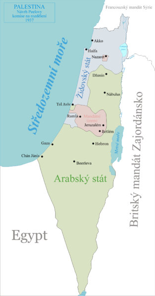
Čeština: Mapa plánu Peelovy komise na rozdělení Palestiny, 1937. *Zelená - navrhovaný Arabský stát *Modrá - navrhovaný Židovský stát *Růžová - navrhovaná mezinárodní neutrální zónaproposed international neutral zone |
||
| Date | (UTC) | ||
| Source | |||
| Author |
|
||
| Permission (Reusing this file) |
I, the copyright holder of this work, hereby publish it under the following license:
|
| This is a retouched picture, which means that it has been digitally altered from its original version. The original can be viewed here: Peel map pd.png:
|
Original upload log[edit]
This image is a derivative work of the following images:
- File:Peel_map_pd.png licensed with PD-self
- 2009-01-04T13:42:28Z Ynhockey 1100x2106 (349129 Bytes) Correction - Tel Aviv was actually in the Jewish state. I thought it was weird, but only now found a map confirming it.
- 2006-08-14T09:51:45Z Ynhockey 1097x2100 (343890 Bytes) Added Nazareth enclave, corrected status from 'International Zone' to 'Mandated Territory'.
- 2006-08-13T18:28:42Z Ynhockey 1097x2100 (339052 Bytes) Map of the Peel Commission partition proposal for Palestine, 1937. *Green - proposed Arab state *Blue - proposed Jewish state *Pink - proposed international neutral zone {{PD-self}}
Uploaded with derivativeFX
File history
Click on a date/time to view the file as it appeared at that time.
| Date/Time | Thumbnail | Dimensions | User | Comment | |
|---|---|---|---|---|---|
| current | 08:08, 21 June 2009 | | 1,100 × 2,106 (233 KB) | Faigl.ladislav (talk | contribs) | {{Information |Description={{cs|Mapa plánu Peelovy komise na rozdělení Palestiny, 1937. *Zelená - navrhovaný Arabský stát *Modrá - navrhovaný Židovský stát *Růžová - navrhovaná mezinárodní neutrální zónaproposed international neutral |
You cannot overwrite this file.
File usage on Commons
There are no pages that use this file.
File usage on other wikis
The following other wikis use this file:
- Usage on cs.wikipedia.org
- Usage on pl.wiktionary.org
- Usage on sk.wikipedia.org