File:Pedra Branca Map.svg
Jump to navigation
Jump to search

Size of this PNG preview of this SVG file: 800 × 487 pixels. Other resolutions: 320 × 195 pixels | 640 × 390 pixels | 1,024 × 624 pixels | 1,280 × 779 pixels | 2,560 × 1,559 pixels | 3,478 × 2,118 pixels.
Original file (SVG file, nominally 3,478 × 2,118 pixels, file size: 230 KB)
Captions
Captions
Add a one-line explanation of what this file represents
Summary
[edit]
| Description |
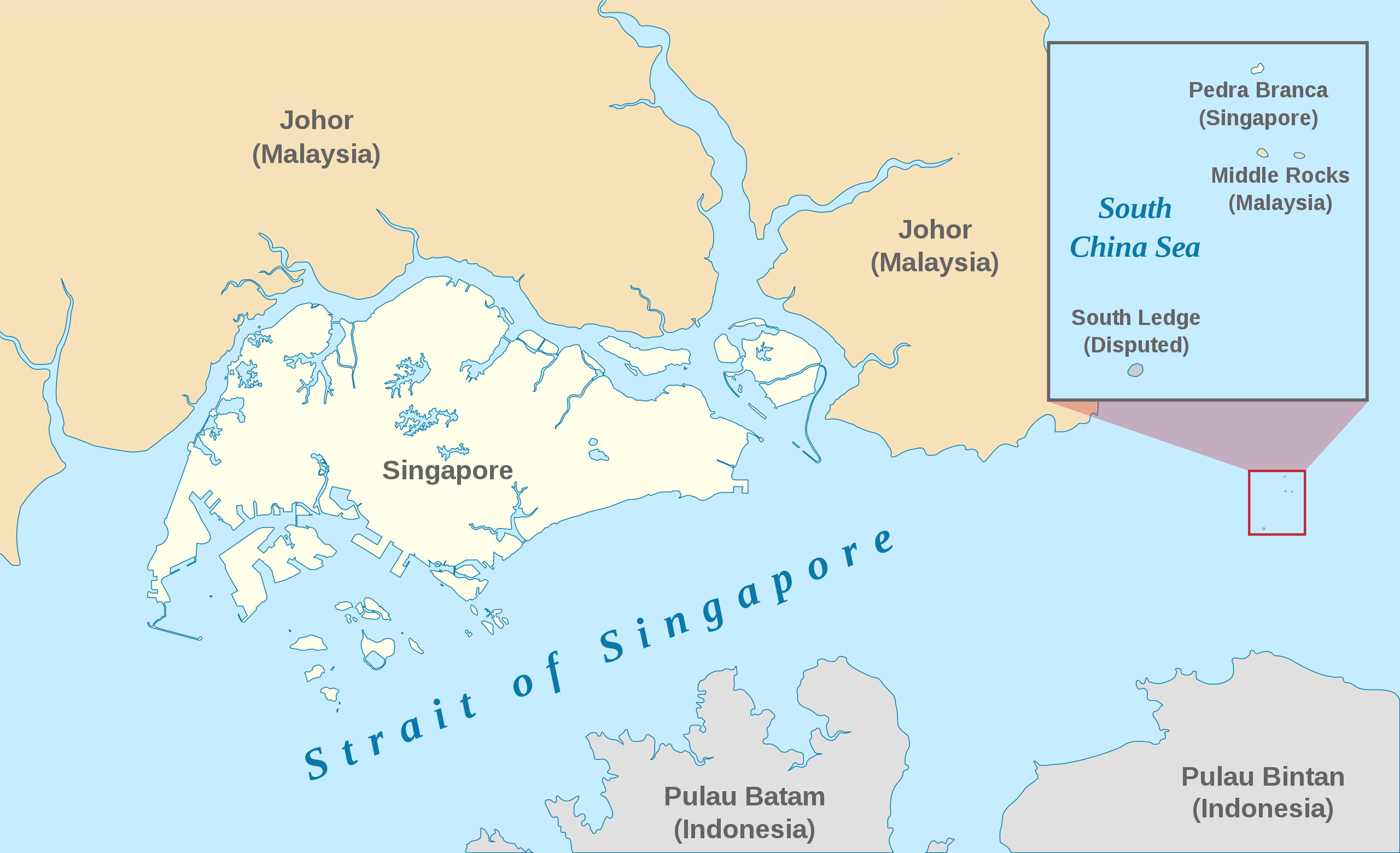
English: A map showing the approximate location of the island of Pedra Branca, which is under the sovereignty of Singapore, at the eastern end of the Singapore Strait where it meets the South China Sea. Near it are the maritime features Middle Rocks (under Malaysian sovereignty) and South Ledge, and the coasts of Johor, Malaysia, and Bintan, Indonesia. |
| Date | |
| Source | Self-made, modified from Image:Singapore Outline.svg. |
| Author | Jappalang. |
| Permission (Reusing this file) |
PD-Self. |
This W3C-unspecified vector image was created with Inkscape .
Licensing
[edit]
| I, the copyright holder of this work, release this work into the public domain. This applies worldwide. In some countries this may not be legally possible; if so: I grant anyone the right to use this work for any purpose, without any conditions, unless such conditions are required by law. |
File history
Click on a date/time to view the file as it appeared at that time.
| Date/Time | Thumbnail | Dimensions | User | Comment | |
|---|---|---|---|---|---|
| current | 06:27, 13 January 2021 | | 3,478 × 2,118 (230 KB) | Seloloving (talk | contribs) | recoloured to Wikipedia map colour style |
| 09:59, 9 February 2020 |  | 3,478 × 2,118 (219 KB) | *angys* (talk | contribs) | File uploaded using svgtranslate tool (https://tools.wmflabs.org/svgtranslate/). Added translation for zh. | |
| 14:36, 22 October 2017 |  | 3,478 × 2,118 (208 KB) | Seloloving (talk | contribs) | Fixed spelling error with "Enlargement" | |
| 14:34, 22 October 2017 |  | 3,478 × 2,118 (208 KB) | Seloloving (talk | contribs) | Recolored claimant states to a more neutral colour. Shifted the Insert Map further up and added note to clarify its actual location. Changed fonts and colours to align with Wikipedia Map guidelines. | |
| 19:42, 24 May 2014 |  | 3,261 × 1,986 (194 KB) | Seloloving (talk | contribs) | Fixed text rendering. Fixed map. | |
| 05:36, 4 May 2014 |  | 3,261 × 1,986 (276 KB) | Seloloving (talk | contribs) | Fixed Johor's shape. | |
| 05:24, 4 May 2014 |  | 3,261 × 1,986 (274 KB) | Seloloving (talk | contribs) | Fixed font problems. | |
| 05:20, 4 May 2014 |  | 3,261 × 1,986 (273 KB) | Seloloving (talk | contribs) | Fixed problems. | |
| 05:12, 4 May 2014 |  | 3,261 × 1,986 (282 KB) | Seloloving (talk | contribs) | Fixed geography of the islands. | |
| 04:05, 30 September 2008 |  | 3,261 × 1,986 (396 KB) | Jappalang (talk | contribs) | "South Lodge" corrected to "South Ledge" |
You cannot overwrite this file.
File usage on Commons
The following page uses this file:
File usage on other wikis
The following other wikis use this file:
- Usage on de.wikipedia.org
- Usage on en.wikipedia.org
- Usage on es.wikipedia.org
- Usage on fr.wikipedia.org
- Usage on he.wikipedia.org
- Usage on id.wikipedia.org
- Usage on it.wikipedia.org
- Usage on ja.wikipedia.org
- Usage on ko.wikipedia.org
- Usage on mdf.wikipedia.org
- Usage on ms.wikipedia.org
- Usage on pt.wikipedia.org
- Usage on ru.wikipedia.org
- Usage on ta.wikipedia.org
- Usage on th.wikipedia.org
- Usage on vi.wikipedia.org
- Usage on zh.wikipedia.org