File:Paris Metro Ligne 12.svg
Jump to navigation
Jump to search

Size of this PNG preview of this SVG file: 480 × 600 pixels. Other resolutions: 192 × 240 pixels | 384 × 480 pixels | 614 × 768 pixels | 819 × 1,024 pixels | 1,638 × 2,048 pixels | 640 × 800 pixels.
Original file (SVG file, nominally 640 × 800 pixels, file size: 48 KB)
Captions
Captions
Add a one-line explanation of what this file represents
Summary[edit]
| Description |
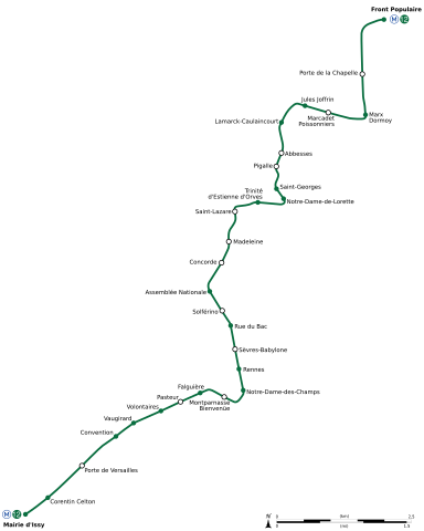
English: Geographically accurate path of Paris Métro Line 12. Français : Plan géographique de la ligne 12 du métro de Paris. |
||
| Date | |||
| Source | File:Ligne 12.gif by Metropolitan under licence Public Domain | ||
| Author | Sémhur (talk) | ||
| Other versions | |||
| SVG |
|
||
| Graphic Lab |

| Object location | | View this and other nearby images on: OpenStreetMap |
|---|
Licensing[edit]
| I, the copyright holder of this work, release this work into the public domain. This applies worldwide. In some countries this may not be legally possible; if so: I grant anyone the right to use this work for any purpose, without any conditions, unless such conditions are required by law. |
File history
Click on a date/time to view the file as it appeared at that time.
| Date/Time | Thumbnail | Dimensions | User | Comment | |
|---|---|---|---|---|---|
| current | 01:26, 29 October 2018 | | 640 × 800 (48 KB) | AlexBurn44 (talk | contribs) | Format |
| 13:05, 11 March 2015 |  | 640 × 800 (49 KB) | Sémhur (talk | contribs) | == {{int:filedesc}} == {{Information |Description={{Multilingual description |en= Geographically accurate path of Paris Métro Line 12. |fr= Plan géographique de la [[:fr:ligne 12 du métro de Paris|ligne 12 du métro de P... |
You cannot overwrite this file.
File usage on Commons
The following 11 pages use this file:
- List of Paris Metro lines
- Maps of Paris
- Paris Metro
- User:Chumwa/OgreBot/Potential transport maps/2018 October 21-31
- User:Chumwa/OgreBot/Public transport information/2015 March 11-20
- User:Chumwa/OgreBot/Public transport information/2018 October 21-31
- User:Chumwa/OgreBot/Transport Maps/2015 March 11-20
- User:Chumwa/OgreBot/Transport Maps/2018 October 21-31
- User:Chumwa/OgreBot/Travel and communication maps/2018 October 21-31
- User:Hoff1980/Rail transport in France/2015 March 11-20
- File:Ligne 12.gif
File usage on other wikis
The following other wikis use this file:
- Usage on ar.wikipedia.org
- Usage on fa.wikipedia.org
- Usage on fr.wikipedia.org
- Usage on ru.wikipedia.org
- Usage on www.wikidata.org