File:Panorama from Kreuzspitze (Ötztaler Alpen).jpg
Jump to navigation
Jump to search

Size of this preview: 800 × 85 pixels. Other resolutions: 320 × 34 pixels | 640 × 68 pixels | 1,024 × 109 pixels | 1,280 × 136 pixels | 2,560 × 271 pixels | 23,948 × 2,538 pixels.
Original file (23,948 × 2,538 pixels, file size: 13.77 MB, MIME type: image/jpeg)
Captions
Captions
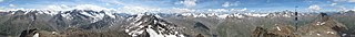
Panorama from Kreuzspitze
Summary[edit]
| Description |
Nederlands: 360° panorama vanop Kreuzspitze in de Ötztaler Alpen.
English: 360° panorama from Kreuzspitze in the Ötztaler Alpen. A view along the mountain chain to Fineilspitze and nearby Hochjoch, a lower region in Schnalskamm mountain chain. In background there some peaks around of Saldurspitze and Schwemser Spitze in Saldurkamm. |
| Date | |
| Source | Own work |
| Author | Trldp |
| Other versions | File:Kreuzspitze (Ötztaler Alpen) rotated.png |
| Camera location | | View this and other nearby images on: OpenStreetMap |
|---|
Licensing[edit]
I, the copyright holder of this work, hereby publish it under the following license:
This file is licensed under the Creative Commons Attribution-Share Alike 4.0 International license.
- You are free:
- to share – to copy, distribute and transmit the work
- to remix – to adapt the work
- Under the following conditions:
- attribution – You must give appropriate credit, provide a link to the license, and indicate if changes were made. You may do so in any reasonable manner, but not in any way that suggests the licensor endorses you or your use.
- share alike – If you remix, transform, or build upon the material, you must distribute your contributions under the same or compatible license as the original.
| Annotations | This image is annotated: View the annotations at Commons |

.jpg&action=edit§ion=1)
_rotated.png)
.jpg¶ms=046.816287_N_0010.870043_E_globe:Earth_type:camera__&language=en)
.jpg&action=edit§ion=2)
.jpg)
File history
Click on a date/time to view the file as it appeared at that time.
| Date/Time | Thumbnail | Dimensions | User | Comment | |
|---|---|---|---|---|---|
| current | 20:12, 25 July 2020 | 23,948 × 2,538 (13.77 MB) | Trldp (talk | contribs) | Uploaded own work with UploadWizard |
You cannot overwrite this file.
File usage on Commons
The following 5 pages use this file:
File usage on other wikis
The following other wikis use this file:
- Usage on kw.wikipedia.org
- Usage on www.wikidata.org
- Usage on xmf.wikipedia.org
.jpg&oldid=858600126)