File:Pannonia02-sr.png
Jump to navigation
Jump to search

Size of this preview: 668 × 599 pixels. Other resolutions: 268 × 240 pixels | 535 × 480 pixels | 1,001 × 898 pixels.
Original file (1,001 × 898 pixels, file size: 75 KB, MIME type: image/png)
Captions
Captions
Add a one-line explanation of what this file represents
Summary[edit]
| Description |
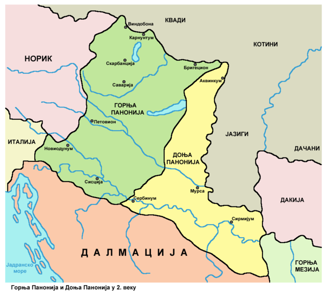
English: Historic map - Roman provinces Pannonia Superior and Pannonia Inferior in the 2nd century. Српски / srpski: Историјска карта - Римске провинције Горња Панонија и Доња Панонија у 2. веку. |
| Date | |
| Source | Own work |
| Author | PANONIAN |
Licensing[edit]
I, the copyright holder of this work, hereby publish it under the following license:
| This file is made available under the Creative Commons CC0 1.0 Universal Public Domain Dedication. | |
| The person who associated a work with this deed has dedicated the work to the public domain by waiving all of their rights to the work worldwide under copyright law, including all related and neighboring rights, to the extent allowed by law. You can copy, modify, distribute and perform the work, even for commercial purposes, all without asking permission.
|
References[edit]
- Dragan Brujić, Vodič kroz Svet antike, Beograd, 2005.
- Denis Šehić - Demir Šehić, Istorijski atlas Sveta, Beograd, 2007.
- The Times History of Europe, Times Books, London, 2002.
- Istorijski atlas, Geokarta, Beograd, 1999.
- Školski istorijski atlas, Zavod za izdavanje udžbenika SR Srbije, Beograd, 1970.
- The Times Atlas Svjetske Povijesti, Cankarjeva založba, Ljubljana - Zagreb, 1986.
- http://ebedszu.net/zsolt/terkep/pannonia_nagy.jpg
- File:Roman provinces of Illyricum, Macedonia, Dacia, Moesia, Pannonia and Thracia.jpg
- File:Roman provinces in a 1867 school atlas.jpg
File history
Click on a date/time to view the file as it appeared at that time.
| Date/Time | Thumbnail | Dimensions | User | Comment | |
|---|---|---|---|---|---|
| current | 10:45, 6 June 2014 | | 1,001 × 898 (75 KB) | PANONIAN (talk | contribs) | changed some names |
| 12:10, 7 January 2014 |  | 1,001 × 898 (75 KB) | PANONIAN (talk | contribs) | {{Information |Description ={{en|1=Historic map - Roman provinces Pannonia Superior and Pannonia Inferior in the 2nd century.}} |Source ={{own}} |Author =PANONIAN |Date =2014 |Permission = |other_versi... |
You cannot overwrite this file.
File usage on Commons
There are no pages that use this file.
File usage on other wikis
The following other wikis use this file:
- Usage on fa.wikipedia.org
- Usage on sr.wikipedia.org